You are here: Home > Network List > TA - USArray Transportable Network (new EarthScope stations) Stations List
> Station E20K Nigu River, AK, USA > Earthquake Result Viewer
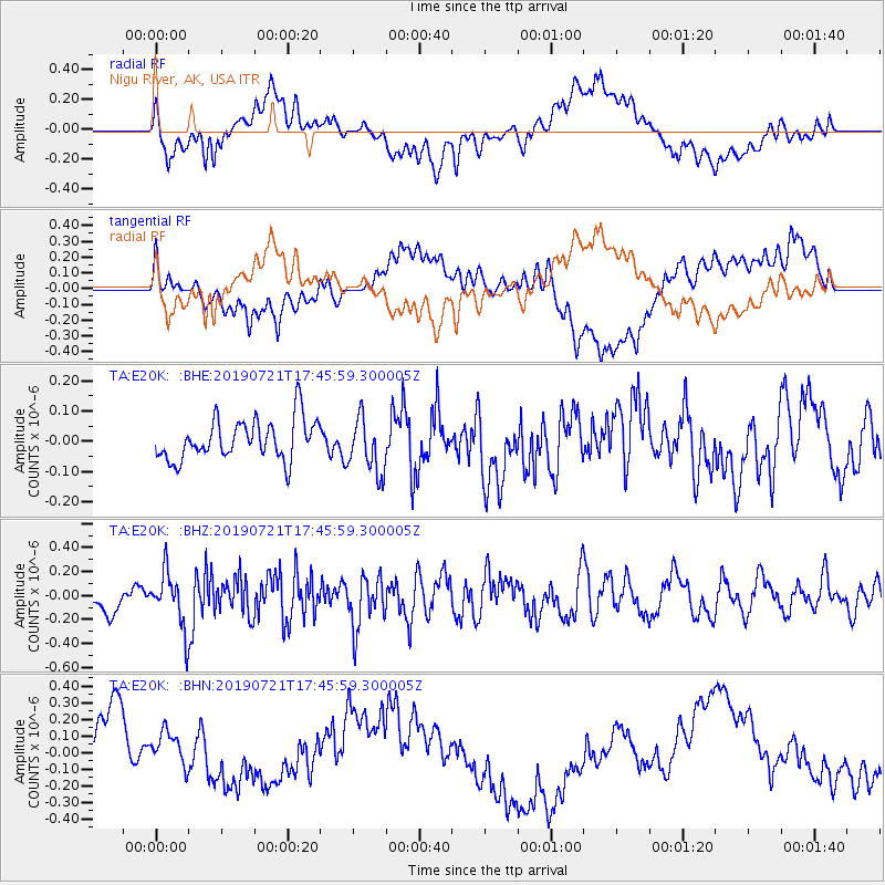
E20K Nigu River, AK, USA - Earthquake Result Viewer
*The percent match for this event was below the threshold and hence no stack was calculated.
| Earthquake location: |
South Of Mariana Islands |
| Earthquake latitude/longitude: |
12.3/144.4 |
| Earthquake time(UTC): |
2019/07/21 (202) 17:35:38 GMT |
| Earthquake Depth: |
48 km |
| Earthquake Magnitude: |
5.5 mb |
| Earthquake Catalog/Contributor: |
NEIC PDE/us |
|
| Network: |
TA USArray Transportable Network (new EarthScope stations) |
| Station: |
E20K Nigu River, AK, USA |
| Lat/Lon: |
68.26 N/156.19 W |
| Elevation: |
866 m |
|
| Distance: |
67.6 deg |
| Az: |
20.297 deg |
| Baz: |
245.518 deg |
| Ray Param: |
$rayparam |
*The percent match for this event was below the threshold and hence was not used in the summary stack. |
|
| Radial Match: |
57.75422 % |
| Radial Bump: |
400 |
| Transverse Match: |
32.887993 % |
| Transverse Bump: |
400 |
| SOD ConfigId: |
19053131 |
| Insert Time: |
2019-08-04 17:41:36.041 +0000 |
| GWidth: |
2.5 |
| Max Bumps: |
400 |
| Tol: |
0.001 |
|
Signal To Noise
| Channel | StoN | STA | LTA |
| TA:E20K: :BHZ:20190721T17:45:59.300005Z | 3.334861 | 2.2998461E-7 | 6.896377E-8 |
| TA:E20K: :BHN:20190721T17:45:59.300005Z | 0.45482 | 1.7278259E-7 | 3.7989224E-7 |
| TA:E20K: :BHE:20190721T17:45:59.300005Z | 1.3827727 | 9.220197E-8 | 6.667905E-8 |
| Arrivals |
| Ps | |
| PpPs | |
| PsPs/PpSs | |


