You are here: Home > Network List > TA - USArray Transportable Network (new EarthScope stations) Stations List
> Station G31M Satah River, YT, CAN > Earthquake Result Viewer
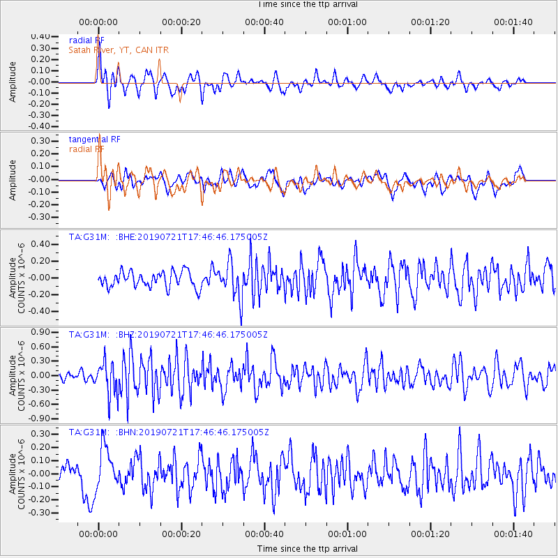
G31M Satah River, YT, CAN - Earthquake Result Viewer
*The percent match for this event was below the threshold and hence no stack was calculated.
| Earthquake location: |
South Of Mariana Islands |
| Earthquake latitude/longitude: |
12.3/144.4 |
| Earthquake time(UTC): |
2019/07/21 (202) 17:35:38 GMT |
| Earthquake Depth: |
48 km |
| Earthquake Magnitude: |
5.5 mb |
| Earthquake Catalog/Contributor: |
NEIC PDE/us |
|
| Network: |
TA USArray Transportable Network (new EarthScope stations) |
| Station: |
G31M Satah River, YT, CAN |
| Lat/Lon: |
66.92 N/134.27 W |
| Elevation: |
61 m |
|
| Distance: |
75.4 deg |
| Az: |
23.746 deg |
| Baz: |
266.895 deg |
| Ray Param: |
$rayparam |
*The percent match for this event was below the threshold and hence was not used in the summary stack. |
|
| Radial Match: |
59.575123 % |
| Radial Bump: |
400 |
| Transverse Match: |
47.122646 % |
| Transverse Bump: |
400 |
| SOD ConfigId: |
19053131 |
| Insert Time: |
2019-08-04 17:41:55.280 +0000 |
| GWidth: |
2.5 |
| Max Bumps: |
400 |
| Tol: |
0.001 |
|
Signal To Noise
| Channel | StoN | STA | LTA |
| TA:G31M: :BHZ:20190721T17:46:46.175005Z | 4.3190284 | 3.520402E-7 | 8.150912E-8 |
| TA:G31M: :BHN:20190721T17:46:46.175005Z | 1.6155274 | 1.5842059E-7 | 9.806122E-8 |
| TA:G31M: :BHE:20190721T17:46:46.175005Z | 2.3613696 | 2.2034166E-7 | 9.331096E-8 |
| Arrivals |
| Ps | |
| PpPs | |
| PsPs/PpSs | |


