You are here: Home > Network List > TA - USArray Transportable Network (new EarthScope stations) Stations List
> Station C05A Tolt Reservoir, WA, USA > Earthquake Result Viewer
C05A Tolt Reservoir, WA, USA - Earthquake Result Viewer
| Earthquake location: |
South Of Fiji Islands |
| Earthquake latitude/longitude: |
-26.0/-177.5 |
| Earthquake time(UTC): |
2007/12/09 (343) 07:28:20 GMT |
| Earthquake Depth: |
152 km |
| Earthquake Magnitude: |
7.0 MB, 7.8 MW, 7.7 MW |
| Earthquake Catalog/Contributor: |
WHDF/NEIC |
|
| Network: |
TA USArray Transportable Network (new EarthScope stations) |
| Station: |
C05A Tolt Reservoir, WA, USA |
| Lat/Lon: |
47.69 N/121.69 W |
| Elevation: |
541 m |
|
| Distance: |
88.8 deg |
| Az: |
33.987 deg |
| Baz: |
228.135 deg |
| Ray Param: |
0.041949768 |
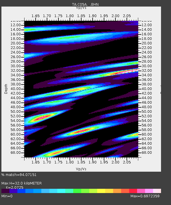
| Estimated Moho Depth: |
32.0 km |
| Estimated Crust Vp/Vs: |
2.07 |
| Assumed Crust Vp: |
6.597 km/s |
| Estimated Crust Vs: |
3.183 km/s |
| Estimated Crust Poisson's Ratio: |
0.35 |
|
| Radial Match: |
94.07151 % |
| Radial Bump: |
400 |
| Transverse Match: |
91.39416 % |
| Transverse Bump: |
400 |
| SOD ConfigId: |
2564 |
| Insert Time: |
2010-03-07 02:04:47.045 +0000 |
| GWidth: |
2.5 |
| Max Bumps: |
400 |
| Tol: |
0.001 |
|

Signal To Noise
| Channel | StoN | STA | LTA |
| TA:C05A: :BHN:20071209T07:40:26.418022Z | 2.5125415 | 3.1412662E-7 | 1.2502346E-7 |
| TA:C05A: :BHE:20071209T07:40:26.418022Z | 3.1122787 | 3.809031E-7 | 1.223872E-7 |
| TA:C05A: :BHZ:20071209T07:40:26.418022Z | 5.7294264 | 1.2395869E-6 | 2.1635445E-7 |
| Arrivals |
| Ps | 5.3 SECOND |
| PpPs | 15 SECOND |
| PsPs/PpSs | 20 SECOND |


