You are here: Home > Network List > US - United States National Seismic Network Stations List
> Station ERPA Erie, Pennsylvania, USA > Earthquake Result Viewer
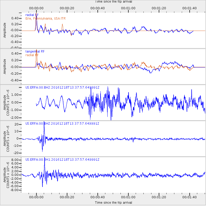
ERPA Erie, Pennsylvania, USA - Earthquake Result Viewer
*The percent match for this event was below the threshold and hence no stack was calculated.
| Earthquake location: |
Peru-Brazil Border Region |
| Earthquake latitude/longitude: |
-10.0/-71.0 |
| Earthquake time(UTC): |
2016/12/18 (353) 13:30:11 GMT |
| Earthquake Depth: |
619 km |
| Earthquake Magnitude: |
6.4 Mww |
| Earthquake Catalog/Contributor: |
NEIC PDE/us |
|
| Network: |
US United States National Seismic Network |
| Station: |
ERPA Erie, Pennsylvania, USA |
| Lat/Lon: |
42.12 N/79.99 W |
| Elevation: |
306 m |
|
| Distance: |
52.5 deg |
| Az: |
351.541 deg |
| Baz: |
168.768 deg |
| Ray Param: |
$rayparam |
*The percent match for this event was below the threshold and hence was not used in the summary stack. |
|
| Radial Match: |
64.51384 % |
| Radial Bump: |
400 |
| Transverse Match: |
54.441364 % |
| Transverse Bump: |
400 |
| SOD ConfigId: |
1894071 |
| Insert Time: |
2017-01-01 13:34:48.733 +0000 |
| GWidth: |
2.5 |
| Max Bumps: |
400 |
| Tol: |
0.001 |
|
Signal To Noise
| Channel | StoN | STA | LTA |
| US:ERPA:00:BHZ:20161218T13:37:57.649991Z | 8.838047 | 4.665699E-6 | 5.2791063E-7 |
| US:ERPA:00:BH1:20161218T13:37:57.649991Z | 3.5515594 | 1.4683469E-6 | 4.1343725E-7 |
| US:ERPA:00:BH2:20161218T13:37:57.649991Z | 1.0469588 | 5.016313E-7 | 4.791318E-7 |
| Arrivals |
| Ps | |
| PpPs | |
| PsPs/PpSs | |


