You are here: Home > Network List > TA - USArray Transportable Network (new EarthScope stations) Stations List
> Station H31M Peel River, Yukon, CAN > Earthquake Result Viewer
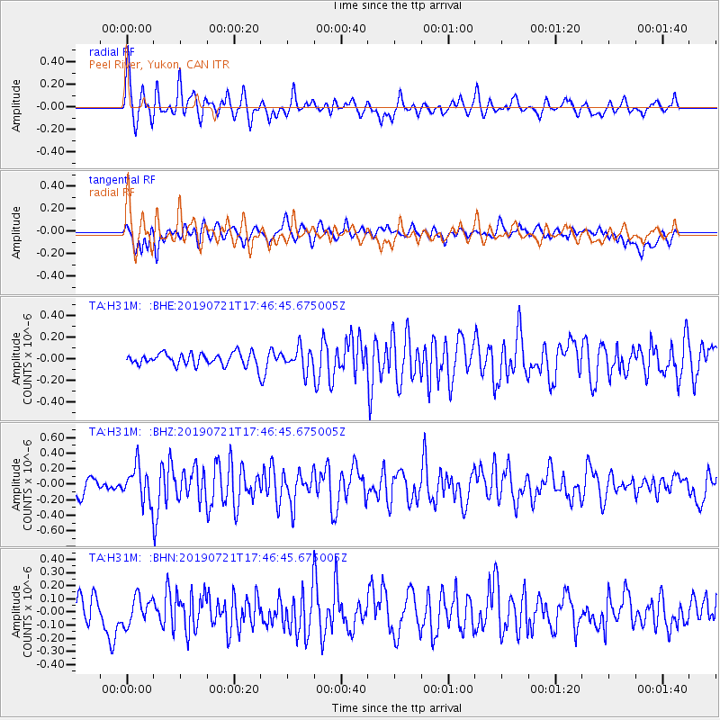
H31M Peel River, Yukon, CAN - Earthquake Result Viewer
*The percent match for this event was below the threshold and hence no stack was calculated.
| Earthquake location: |
South Of Mariana Islands |
| Earthquake latitude/longitude: |
12.3/144.4 |
| Earthquake time(UTC): |
2019/07/21 (202) 17:35:38 GMT |
| Earthquake Depth: |
48 km |
| Earthquake Magnitude: |
5.5 mb |
| Earthquake Catalog/Contributor: |
NEIC PDE/us |
|
| Network: |
TA USArray Transportable Network (new EarthScope stations) |
| Station: |
H31M Peel River, Yukon, CAN |
| Lat/Lon: |
65.81 N/134.34 W |
| Elevation: |
642 m |
|
| Distance: |
75.3 deg |
| Az: |
24.903 deg |
| Baz: |
267.121 deg |
| Ray Param: |
$rayparam |
*The percent match for this event was below the threshold and hence was not used in the summary stack. |
|
| Radial Match: |
76.232925 % |
| Radial Bump: |
400 |
| Transverse Match: |
53.382557 % |
| Transverse Bump: |
400 |
| SOD ConfigId: |
19053131 |
| Insert Time: |
2019-08-04 17:42:01.877 +0000 |
| GWidth: |
2.5 |
| Max Bumps: |
400 |
| Tol: |
0.001 |
|
Signal To Noise
| Channel | StoN | STA | LTA |
| TA:H31M: :BHZ:20190721T17:46:45.675005Z | 2.5054953 | 2.2582094E-7 | 9.0130264E-8 |
| TA:H31M: :BHN:20190721T17:46:45.675005Z | 1.0661246 | 1.0361153E-7 | 9.718519E-8 |
| TA:H31M: :BHE:20190721T17:46:45.675005Z | 1.8193575 | 1.013285E-7 | 5.5694663E-8 |
| Arrivals |
| Ps | |
| PpPs | |
| PsPs/PpSs | |


