You are here: Home > Network List > TA - USArray Transportable Network (new EarthScope stations) Stations List
> Station I30M Mount Dempster, Yukon, CAN > Earthquake Result Viewer
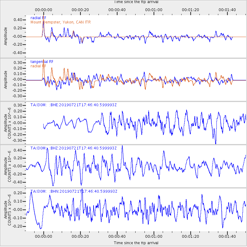
I30M Mount Dempster, Yukon, CAN - Earthquake Result Viewer
*The percent match for this event was below the threshold and hence no stack was calculated.
| Earthquake location: |
South Of Mariana Islands |
| Earthquake latitude/longitude: |
12.3/144.4 |
| Earthquake time(UTC): |
2019/07/21 (202) 17:35:38 GMT |
| Earthquake Depth: |
48 km |
| Earthquake Magnitude: |
5.5 mb |
| Earthquake Catalog/Contributor: |
NEIC PDE/us |
|
| Network: |
TA USArray Transportable Network (new EarthScope stations) |
| Station: |
I30M Mount Dempster, Yukon, CAN |
| Lat/Lon: |
65.22 N/136.38 W |
| Elevation: |
1399 m |
|
| Distance: |
74.4 deg |
| Az: |
25.451 deg |
| Baz: |
265.415 deg |
| Ray Param: |
$rayparam |
*The percent match for this event was below the threshold and hence was not used in the summary stack. |
|
| Radial Match: |
70.85673 % |
| Radial Bump: |
400 |
| Transverse Match: |
36.712914 % |
| Transverse Bump: |
400 |
| SOD ConfigId: |
19053131 |
| Insert Time: |
2019-08-04 17:42:06.108 +0000 |
| GWidth: |
2.5 |
| Max Bumps: |
400 |
| Tol: |
0.001 |
|
Signal To Noise
| Channel | StoN | STA | LTA |
| TA:I30M: :BHZ:20190721T17:46:40.599993Z | 4.4748344 | 2.2895686E-7 | 5.116544E-8 |
| TA:I30M: :BHN:20190721T17:46:40.599993Z | 0.9479441 | 8.692792E-8 | 9.170152E-8 |
| TA:I30M: :BHE:20190721T17:46:40.599993Z | 1.7248719 | 9.7041834E-8 | 5.6260312E-8 |
| Arrivals |
| Ps | |
| PpPs | |
| PsPs/PpSs | |


