You are here: Home > Network List > TA - USArray Transportable Network (new EarthScope stations) Stations List
> Station C05A Tolt Reservoir, WA, USA > Earthquake Result Viewer
C05A Tolt Reservoir, WA, USA - Earthquake Result Viewer
| Earthquake location: |
Taiwan Region |
| Earthquake latitude/longitude: |
24.3/122.2 |
| Earthquake time(UTC): |
2007/09/06 (249) 17:51:26 GMT |
| Earthquake Depth: |
53 km |
| Earthquake Magnitude: |
6.1 MB, 6.2 MW, 6.1 ME |
| Earthquake Catalog/Contributor: |
WHDF/NEIC |
|
| Network: |
TA USArray Transportable Network (new EarthScope stations) |
| Station: |
C05A Tolt Reservoir, WA, USA |
| Lat/Lon: |
47.69 N/121.69 W |
| Elevation: |
541 m |
|
| Distance: |
88.2 deg |
| Az: |
37.373 deg |
| Baz: |
304.956 deg |
| Ray Param: |
0.042662833 |
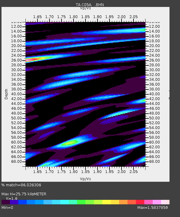
| Estimated Moho Depth: |
25.75 km |
| Estimated Crust Vp/Vs: |
1.60 |
| Assumed Crust Vp: |
6.597 km/s |
| Estimated Crust Vs: |
4.123 km/s |
| Estimated Crust Poisson's Ratio: |
0.18 |
|
| Radial Match: |
86.026306 % |
| Radial Bump: |
400 |
| Transverse Match: |
91.82836 % |
| Transverse Bump: |
400 |
| SOD ConfigId: |
2564 |
| Insert Time: |
2010-03-07 02:05:02.559 +0000 |
| GWidth: |
2.5 |
| Max Bumps: |
400 |
| Tol: |
0.001 |
|

Signal To Noise
| Channel | StoN | STA | LTA |
| TA:C05A: :BHN:20070906T18:03:40.395017Z | 6.301417 | 7.9922995E-7 | 1.2683337E-7 |
| TA:C05A: :BHE:20070906T18:03:40.395017Z | 2.9616005 | 5.826622E-7 | 1.9673895E-7 |
| TA:C05A: :BHZ:20070906T18:03:40.395017Z | 20.805115 | 2.5477484E-6 | 1.2245779E-7 |
| Arrivals |
| Ps | 2.4 SECOND |
| PpPs | 9.9 SECOND |
| PsPs/PpSs | 12 SECOND |


