You are here: Home > Network List > TA - USArray Transportable Network (new EarthScope stations) Stations List
> Station C05A Tolt Reservoir, WA, USA > Earthquake Result Viewer
C05A Tolt Reservoir, WA, USA - Earthquake Result Viewer
| Earthquake location: |
Near Coast Of Peru |
| Earthquake latitude/longitude: |
-13.4/-76.6 |
| Earthquake time(UTC): |
2007/08/15 (227) 23:40:57 GMT |
| Earthquake Depth: |
39 km |
| Earthquake Magnitude: |
6.7 MB, 7.9 MS, 8.0 MW, 7.5 ME |
| Earthquake Catalog/Contributor: |
WHDF/NEIC |
|
| Network: |
TA USArray Transportable Network (new EarthScope stations) |
| Station: |
C05A Tolt Reservoir, WA, USA |
| Lat/Lon: |
47.69 N/121.69 W |
| Elevation: |
541 m |
|
| Distance: |
72.9 deg |
| Az: |
329.959 deg |
| Baz: |
133.848 deg |
| Ray Param: |
0.053314086 |
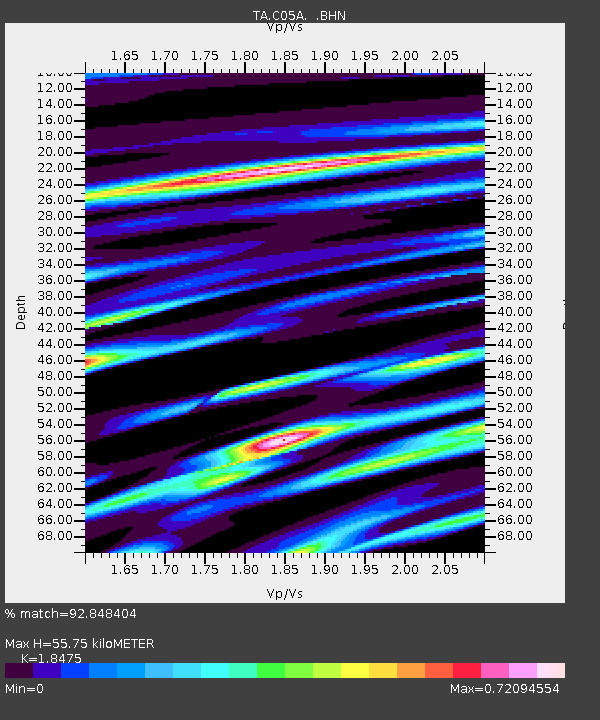
| Estimated Moho Depth: |
55.75 km |
| Estimated Crust Vp/Vs: |
1.85 |
| Assumed Crust Vp: |
6.597 km/s |
| Estimated Crust Vs: |
3.571 km/s |
| Estimated Crust Poisson's Ratio: |
0.29 |
|
| Radial Match: |
92.848404 % |
| Radial Bump: |
400 |
| Transverse Match: |
81.162636 % |
| Transverse Bump: |
400 |
| SOD ConfigId: |
2564 |
| Insert Time: |
2010-03-07 02:05:11.548 +0000 |
| GWidth: |
2.5 |
| Max Bumps: |
400 |
| Tol: |
0.001 |
|

Signal To Noise
| Channel | StoN | STA | LTA |
| TA:C05A: :BHN:20070815T23:51:51.869004Z | 10.170102 | 8.745345E-7 | 8.5990735E-8 |
| TA:C05A: :BHE:20070815T23:51:51.869004Z | 8.7694435 | 7.941513E-7 | 9.055891E-8 |
| TA:C05A: :BHZ:20070815T23:51:51.869004Z | 35.20336 | 2.9820173E-6 | 8.470832E-8 |
| Arrivals |
| Ps | 7.4 SECOND |
| PpPs | 23 SECOND |
| PsPs/PpSs | 31 SECOND |


