You are here: Home > Network List > TA - USArray Transportable Network (new EarthScope stations) Stations List
> Station P17K Kvichak River, AK, USA > Earthquake Result Viewer
P17K Kvichak River, AK, USA - Earthquake Result Viewer
*The percent match for this event was below the threshold and hence no stack was calculated.
| Earthquake location: |
South Of Mariana Islands |
| Earthquake latitude/longitude: |
12.3/144.4 |
| Earthquake time(UTC): |
2019/07/21 (202) 17:35:38 GMT |
| Earthquake Depth: |
48 km |
| Earthquake Magnitude: |
5.5 mb |
| Earthquake Catalog/Contributor: |
NEIC PDE/us |
|
| Network: |
TA USArray Transportable Network (new EarthScope stations) |
| Station: |
P17K Kvichak River, AK, USA |
| Lat/Lon: |
59.20 N/156.44 W |
| Elevation: |
91 m |
|
| Distance: |
64.0 deg |
| Az: |
29.453 deg |
| Baz: |
249.056 deg |
| Ray Param: |
$rayparam |
*The percent match for this event was below the threshold and hence was not used in the summary stack. |
|
| Radial Match: |
64.469345 % |
| Radial Bump: |
400 |
| Transverse Match: |
51.387756 % |
| Transverse Bump: |
400 |
| SOD ConfigId: |
19053131 |
| Insert Time: |
2019-08-04 17:42:39.881 +0000 |
| GWidth: |
2.5 |
| Max Bumps: |
400 |
| Tol: |
0.001 |
|
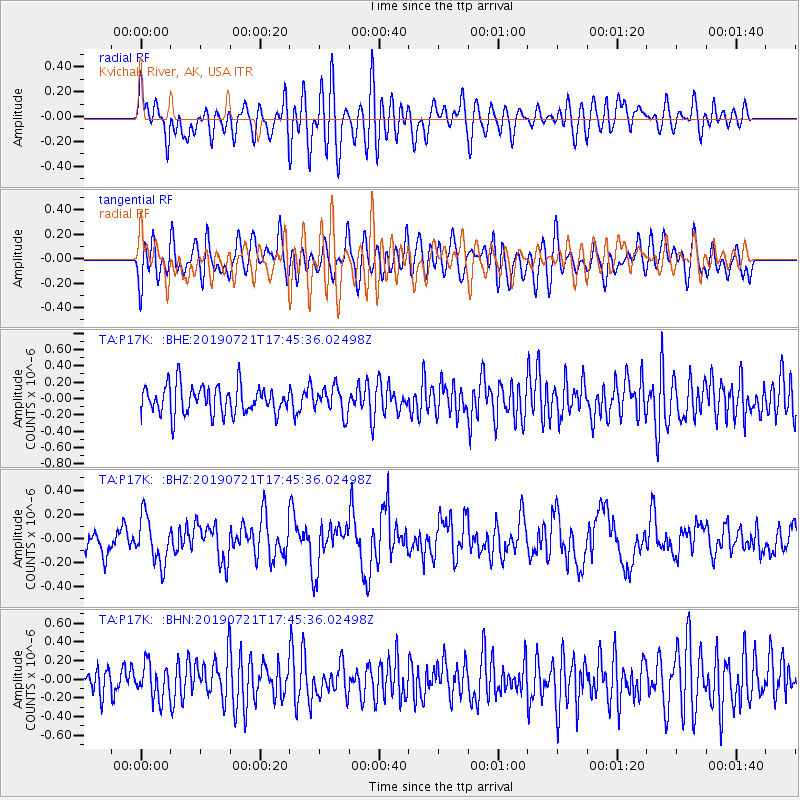
Signal To Noise
| Channel | StoN | STA | LTA |
| TA:P17K: :BHZ:20190721T17:45:36.02498Z | 2.1375775 | 1.9156153E-7 | 8.961617E-8 |
| TA:P17K: :BHN:20190721T17:45:36.02498Z | 1.0435722 | 1.7966212E-7 | 1.721607E-7 |
| TA:P17K: :BHE:20190721T17:45:36.02498Z | 0.9386507 | 1.6248296E-7 | 1.7310268E-7 |
| Arrivals |
| Ps | |
| PpPs | |
| PsPs/PpSs | |


