You are here: Home > Network List > TA - USArray Transportable Network (new EarthScope stations) Stations List
> Station C05A Tolt Reservoir, WA, USA > Earthquake Result Viewer
C05A Tolt Reservoir, WA, USA - Earthquake Result Viewer
| Earthquake location: |
Sea Of Japan |
| Earthquake latitude/longitude: |
36.8/134.9 |
| Earthquake time(UTC): |
2007/07/16 (197) 14:17:37 GMT |
| Earthquake Depth: |
350 km |
| Earthquake Magnitude: |
6.2 MB, 6.8 MW, 6.8 MW |
| Earthquake Catalog/Contributor: |
WHDF/NEIC |
|
| Network: |
TA USArray Transportable Network (new EarthScope stations) |
| Station: |
C05A Tolt Reservoir, WA, USA |
| Lat/Lon: |
47.69 N/121.69 W |
| Elevation: |
541 m |
|
| Distance: |
71.7 deg |
| Az: |
43.781 deg |
| Baz: |
304.714 deg |
| Ray Param: |
0.05309573 |
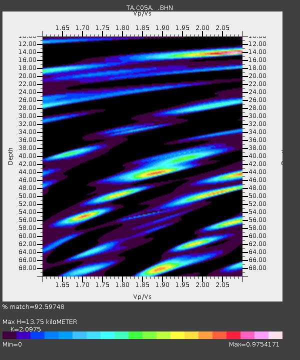
| Estimated Moho Depth: |
13.75 km |
| Estimated Crust Vp/Vs: |
2.10 |
| Assumed Crust Vp: |
6.597 km/s |
| Estimated Crust Vs: |
3.145 km/s |
| Estimated Crust Poisson's Ratio: |
0.35 |
|
| Radial Match: |
92.59748 % |
| Radial Bump: |
400 |
| Transverse Match: |
85.604576 % |
| Transverse Bump: |
400 |
| SOD ConfigId: |
2564 |
| Insert Time: |
2010-03-07 02:05:20.598 +0000 |
| GWidth: |
2.5 |
| Max Bumps: |
400 |
| Tol: |
0.001 |
|

Signal To Noise
| Channel | StoN | STA | LTA |
| TA:C05A: :BHN:20070716T14:27:51.144016Z | 11.267432 | 1.0026096E-6 | 8.898297E-8 |
| TA:C05A: :BHE:20070716T14:27:51.144016Z | 19.772669 | 1.689792E-6 | 8.5461004E-8 |
| TA:C05A: :BHZ:20070716T14:27:51.144016Z | 39.11223 | 3.623056E-6 | 9.2632305E-8 |
| Arrivals |
| Ps | 2.4 SECOND |
| PpPs | 6.3 SECOND |
| PsPs/PpSs | 8.6 SECOND |


