You are here: Home > Network List > US - United States National Seismic Network Stations List
> Station NEW Newport, Washington, USA > Earthquake Result Viewer
NEW Newport, Washington, USA - Earthquake Result Viewer
*The percent match for this event was below the threshold and hence no stack was calculated.
| Earthquake location: |
South Of Mariana Islands |
| Earthquake latitude/longitude: |
12.3/144.4 |
| Earthquake time(UTC): |
2019/07/21 (202) 17:35:38 GMT |
| Earthquake Depth: |
48 km |
| Earthquake Magnitude: |
5.5 mb |
| Earthquake Catalog/Contributor: |
NEIC PDE/us |
|
| Network: |
US United States National Seismic Network |
| Station: |
NEW Newport, Washington, USA |
| Lat/Lon: |
48.26 N/117.12 W |
| Elevation: |
760 m |
|
| Distance: |
86.5 deg |
| Az: |
41.462 deg |
| Baz: |
284.39 deg |
| Ray Param: |
$rayparam |
*The percent match for this event was below the threshold and hence was not used in the summary stack. |
|
| Radial Match: |
55.27907 % |
| Radial Bump: |
400 |
| Transverse Match: |
45.49814 % |
| Transverse Bump: |
400 |
| SOD ConfigId: |
19053131 |
| Insert Time: |
2019-08-04 17:43:06.720 +0000 |
| GWidth: |
2.5 |
| Max Bumps: |
400 |
| Tol: |
0.001 |
|
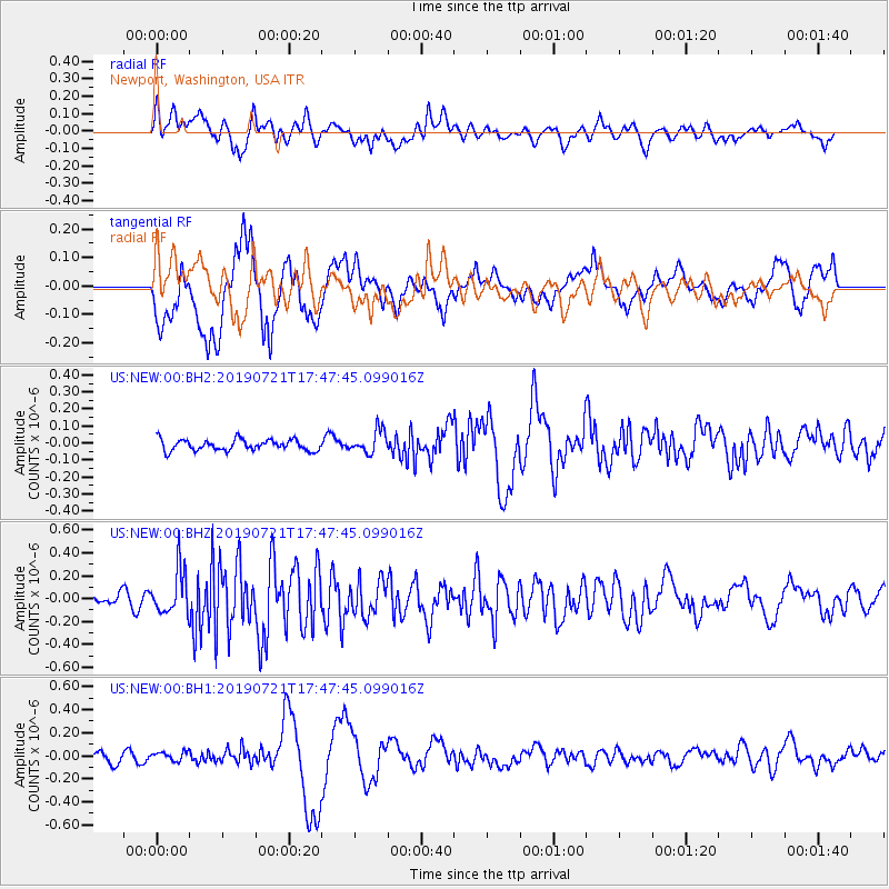
Signal To Noise
| Channel | StoN | STA | LTA |
| US:NEW:00:BHZ:20190721T17:47:45.099016Z | 4.2486124 | 1.9311702E-7 | 4.5454136E-8 |
| US:NEW:00:BH1:20190721T17:47:45.099016Z | 0.88795924 | 3.7731947E-8 | 4.2492886E-8 |
| US:NEW:00:BH2:20190721T17:47:45.099016Z | 2.080069 | 6.7037355E-8 | 3.2228424E-8 |
| Arrivals |
| Ps | |
| PpPs | |
| PsPs/PpSs | |


