You are here: Home > Network List > UW - Pacific Northwest Regional Seismic Network Stations List
> Station UMAT Pilot Rock, OR, USA > Earthquake Result Viewer
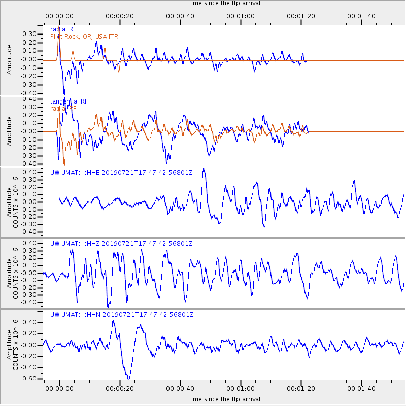
UMAT Pilot Rock, OR, USA - Earthquake Result Viewer
*The percent match for this event was below the threshold and hence no stack was calculated.
| Earthquake location: |
South Of Mariana Islands |
| Earthquake latitude/longitude: |
12.3/144.4 |
| Earthquake time(UTC): |
2019/07/21 (202) 17:35:38 GMT |
| Earthquake Depth: |
48 km |
| Earthquake Magnitude: |
5.5 mb |
| Earthquake Catalog/Contributor: |
NEIC PDE/us |
|
| Network: |
UW Pacific Northwest Regional Seismic Network |
| Station: |
UMAT Pilot Rock, OR, USA |
| Lat/Lon: |
45.29 N/118.96 W |
| Elevation: |
1318 m |
|
| Distance: |
86.0 deg |
| Az: |
44.659 deg |
| Baz: |
283.261 deg |
| Ray Param: |
$rayparam |
*The percent match for this event was below the threshold and hence was not used in the summary stack. |
|
| Radial Match: |
82.879974 % |
| Radial Bump: |
400 |
| Transverse Match: |
66.60332 % |
| Transverse Bump: |
400 |
| SOD ConfigId: |
19053131 |
| Insert Time: |
2019-08-04 17:43:37.286 +0000 |
| GWidth: |
2.5 |
| Max Bumps: |
400 |
| Tol: |
0.001 |
|
Signal To Noise
| Channel | StoN | STA | LTA |
| UW:UMAT: :HHZ:20190721T17:47:42.56801Z | 4.805338 | 1.4588556E-7 | 3.0359065E-8 |
| UW:UMAT: :HHN:20190721T17:47:42.56801Z | 1.4877373 | 3.836887E-8 | 2.5790085E-8 |
| UW:UMAT: :HHE:20190721T17:47:42.56801Z | 1.434547 | 5.7304874E-8 | 3.9946322E-8 |
| Arrivals |
| Ps | |
| PpPs | |
| PsPs/PpSs | |


