You are here: Home > Network List > TA - USArray Transportable Network (new EarthScope stations) Stations List
> Station C05A Tolt Reservoir, WA, USA > Earthquake Result Viewer
C05A Tolt Reservoir, WA, USA - Earthquake Result Viewer
| Earthquake location: |
Solomon Islands |
| Earthquake latitude/longitude: |
-6.8/155.5 |
| Earthquake time(UTC): |
2006/09/01 (244) 10:18:51 GMT |
| Earthquake Depth: |
38 km |
| Earthquake Magnitude: |
6.3 MB, 6.7 MS, 6.8 MW, 6.7 MW |
| Earthquake Catalog/Contributor: |
WHDF/NEIC |
|
| Network: |
TA USArray Transportable Network (new EarthScope stations) |
| Station: |
C05A Tolt Reservoir, WA, USA |
| Lat/Lon: |
47.69 N/121.69 W |
| Elevation: |
541 m |
|
| Distance: |
90.1 deg |
| Az: |
42.084 deg |
| Baz: |
260.167 deg |
| Ray Param: |
0.041691005 |
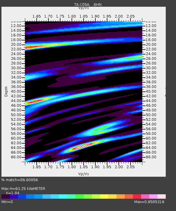
| Estimated Moho Depth: |
63.25 km |
| Estimated Crust Vp/Vs: |
1.84 |
| Assumed Crust Vp: |
6.597 km/s |
| Estimated Crust Vs: |
3.586 km/s |
| Estimated Crust Poisson's Ratio: |
0.29 |
|
| Radial Match: |
86.60856 % |
| Radial Bump: |
400 |
| Transverse Match: |
61.748577 % |
| Transverse Bump: |
400 |
| SOD ConfigId: |
2665 |
| Insert Time: |
2010-03-07 02:05:54.586 +0000 |
| GWidth: |
2.5 |
| Max Bumps: |
400 |
| Tol: |
0.001 |
|

Signal To Noise
| Channel | StoN | STA | LTA |
| TA:C05A: :BHN:20060901T10:31:16.443018Z | 1.1496576 | 1.320599E-7 | 1.148689E-7 |
| TA:C05A: :BHE:20060901T10:31:16.443018Z | 4.645931 | 4.1924918E-7 | 9.0240086E-8 |
| TA:C05A: :BHZ:20060901T10:31:16.443018Z | 14.275199 | 1.1912132E-6 | 8.3446345E-8 |
| Arrivals |
| Ps | 8.2 SECOND |
| PpPs | 27 SECOND |
| PsPs/PpSs | 35 SECOND |


