You are here: Home > Network List > TA - USArray Transportable Network (new EarthScope stations) Stations List
> Station H04A Detroit Lake, OR, USA > Earthquake Result Viewer
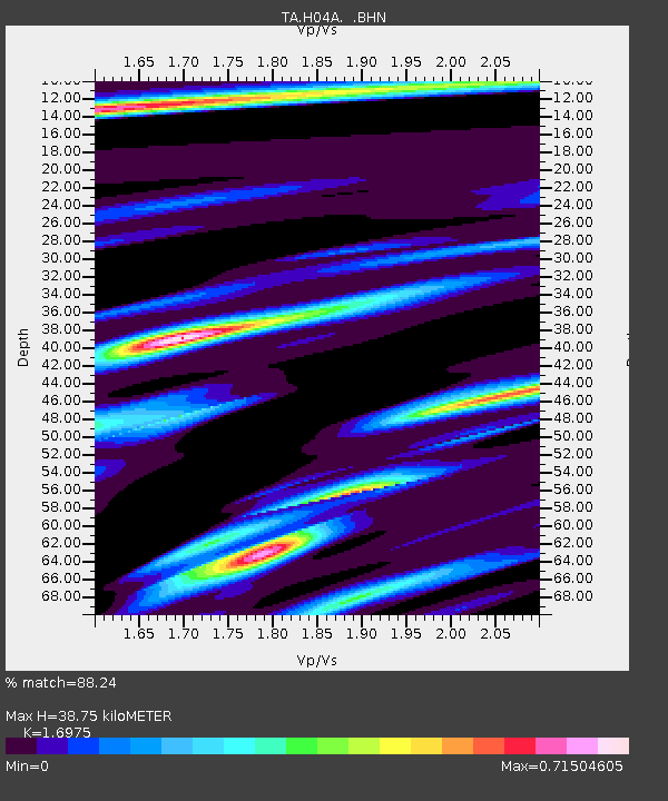
H04A Detroit Lake, OR, USA - Earthquake Result Viewer
| Earthquake location: |
Chile-Bolivia Border Region |
| Earthquake latitude/longitude: |
-22.3/-67.9 |
| Earthquake time(UTC): |
2005/11/17 (321) 19:26:56 GMT |
| Earthquake Depth: |
163 km |
| Earthquake Magnitude: |
6.0 MB, 6.9 MW, 6.8 MW |
| Earthquake Catalog/Contributor: |
WHDF/NEIC |
|
| Network: |
TA USArray Transportable Network (new EarthScope stations) |
| Station: |
H04A Detroit Lake, OR, USA |
| Lat/Lon: |
44.68 N/122.19 W |
| Elevation: |
652 m |
|
| Distance: |
83.1 deg |
| Az: |
324.297 deg |
| Baz: |
130.754 deg |
| Ray Param: |
0.04607176 |
| Estimated Moho Depth: |
38.75 km |
| Estimated Crust Vp/Vs: |
1.70 |
| Assumed Crust Vp: |
6.566 km/s |
| Estimated Crust Vs: |
3.868 km/s |
| Estimated Crust Poisson's Ratio: |
0.23 |
|
| Radial Match: |
88.24 % |
| Radial Bump: |
400 |
| Transverse Match: |
82.559006 % |
| Transverse Bump: |
400 |
| SOD ConfigId: |
2422 |
| Insert Time: |
2010-03-07 02:06:35.081 +0000 |
| GWidth: |
2.5 |
| Max Bumps: |
400 |
| Tol: |
0.001 |
|

Signal To Noise
| Channel | StoN | STA | LTA |
| TA:H04A: :BHN:20051117T19:38:32.57502Z | 6.0894685 | 1.1859122E-6 | 1.9474807E-7 |
| TA:H04A: :BHE:20051117T19:38:32.57502Z | 4.806778 | 9.994311E-7 | 2.079212E-7 |
| TA:H04A: :BHZ:20051117T19:38:32.57502Z | 15.340844 | 5.4040684E-6 | 3.5226668E-7 |
| Arrivals |
| Ps | 4.2 SECOND |
| PpPs | 15 SECOND |
| PsPs/PpSs | 20 SECOND |


