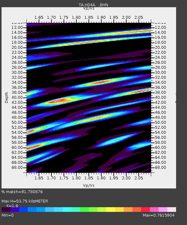
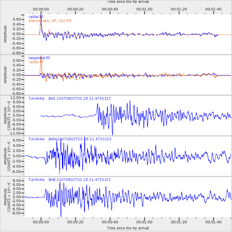
H04A Detroit Lake, OR, USA - Earthquake Result Viewer

Earthquake location: Andreanof Islands, Aleutian Is.
Earthquake latitude/longitude: 51.3/-180.0
Earthquake time(UTC): 2007/08/02 (214) 03:21:42 GMT
Earthquake Depth: 21 km
Earthquake Magnitude: 6.3 MB, 6.6 MS, 6.7 MW, 6.6 MW
Earthquake Catalog/Contributor: WHDF/NEIC
Network: TA USArray Transportable Network (new EarthScope stations)
Station: H04A Detroit Lake, OR, USA
Lat/Lon: 44.68 N/122.19 W
Elevation: 652 m
Distance: 38.3 deg
Az: 76.593 deg
Baz: 301.135 deg
Ray Param: 0.07558508
Estimated Moho Depth: 53.75 km
Estimated Crust Vp/Vs: 1.60
Assumed Crust Vp: 6.566 km/s
Estimated Crust Vs: 4.104 km/s
Estimated Crust Poisson's Ratio: 0.18
Radial Match: 91.780876 %
Radial Bump: 400
Transverse Match: 74.987564 %
Transverse Bump: 400
SOD ConfigId: 2564
Insert Time: 2010-03-07 02:07:12.773 +0000
GWidth: 2.5
Max Bumps: 400
Tol: 0.001

Signal To Noise

ChannelStoNSTALTA
TA:H04A: :BHN:20070802T03:28:31.473015Z2.88152151.1749696E-64.0776015E-7
TA:H04A: :BHE:20070802T03:28:31.473015Z7.6725541.5557268E-62.027652E-7
TA:H04A: :BHZ:20070802T03:28:31.473015Z6.2161243.089245E-64.9697286E-7
Arrivals
Ps5.3 SECOND
PpPs20 SECOND
PsPs/PpSs25 SECOND