You are here: Home > Network List > CN - Canadian National Seismograph Network Stations List
> Station INK INUVIK, NT > Earthquake Result Viewer
INK INUVIK, NT - Earthquake Result Viewer
*The percent match for this event was below the threshold and hence no stack was calculated.
| Earthquake location: |
Northeast Of Taiwan |
| Earthquake latitude/longitude: |
25.3/124.4 |
| Earthquake time(UTC): |
2019/07/22 (203) 20:46:58 GMT |
| Earthquake Depth: |
100 km |
| Earthquake Magnitude: |
5.1 Mww |
| Earthquake Catalog/Contributor: |
NEIC PDE/us |
|
| Network: |
CN Canadian National Seismograph Network |
| Station: |
INK INUVIK, NT |
| Lat/Lon: |
68.31 N/133.53 W |
| Elevation: |
44 m |
|
| Distance: |
71.1 deg |
| Az: |
22.591 deg |
| Baz: |
290.675 deg |
| Ray Param: |
$rayparam |
*The percent match for this event was below the threshold and hence was not used in the summary stack. |
|
| Radial Match: |
44.293526 % |
| Radial Bump: |
400 |
| Transverse Match: |
40.389194 % |
| Transverse Bump: |
400 |
| SOD ConfigId: |
19053131 |
| Insert Time: |
2019-08-05 20:50:22.707 +0000 |
| GWidth: |
2.5 |
| Max Bumps: |
400 |
| Tol: |
0.001 |
|
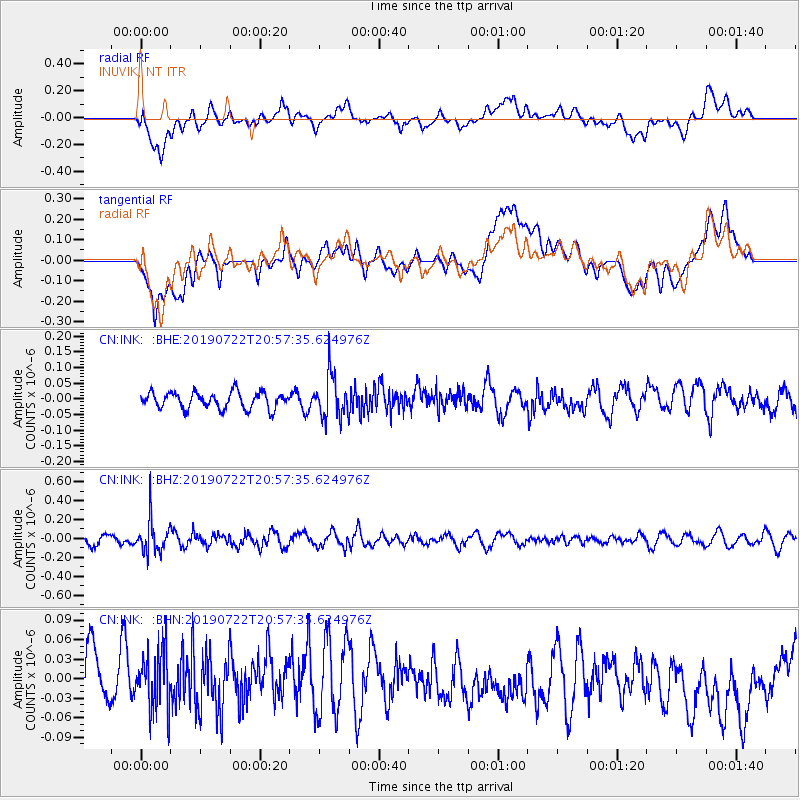
Signal To Noise
| Channel | StoN | STA | LTA |
| CN:INK: :BHZ:20190722T20:57:35.624976Z | 4.2619824 | 1.8037998E-7 | 4.2323027E-8 |
| CN:INK: :BHN:20190722T20:57:35.624976Z | 1.0876144 | 4.4949076E-8 | 4.1328136E-8 |
| CN:INK: :BHE:20190722T20:57:35.624976Z | 2.6453335 | 6.955304E-8 | 2.629273E-8 |
| Arrivals |
| Ps | |
| PpPs | |
| PsPs/PpSs | |


