You are here: Home > Network List > TA - USArray Transportable Network (new EarthScope stations) Stations List
> Station H04A Detroit Lake, OR, USA > Earthquake Result Viewer
H04A Detroit Lake, OR, USA - Earthquake Result Viewer

| Earthquake location: |
Kuril Islands |
| Earthquake latitude/longitude: |
46.6/153.3 |
| Earthquake time(UTC): |
2006/11/15 (319) 11:14:13 GMT |
| Earthquake Depth: |
10 km |
| Earthquake Magnitude: |
6.5 MB, 7.8 MS, 8.3 MW, 7.9 MW |
| Earthquake Catalog/Contributor: |
WHDF/NEIC |
|
| Network: |
TA USArray Transportable Network (new EarthScope stations) |
| Station: |
H04A Detroit Lake, OR, USA |
| Lat/Lon: |
44.68 N/122.19 W |
| Elevation: |
652 m |
|
| Distance: |
56.3 deg |
| Az: |
58.557 deg |
| Baz: |
304.435 deg |
| Ray Param: |
0.06420482 |
| Estimated Moho Depth: |
69.75 km |
| Estimated Crust Vp/Vs: |
2.05 |
| Assumed Crust Vp: |
6.566 km/s |
| Estimated Crust Vs: |
3.203 km/s |
| Estimated Crust Poisson's Ratio: |
0.34 |
|
| Radial Match: |
98.38365 % |
| Radial Bump: |
243 |
| Transverse Match: |
93.15354 % |
| Transverse Bump: |
400 |
| SOD ConfigId: |
2564 |
| Insert Time: |
2010-03-07 02:07:20.057 +0000 |
| GWidth: |
2.5 |
| Max Bumps: |
400 |
| Tol: |
0.001 |
|
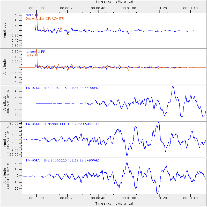
Signal To Noise
| Channel | StoN | STA | LTA |
| TA:H04A: :BHN:20061115T11:23:23.549004Z | 2.5403283 | 9.442232E-7 | 3.7169335E-7 |
| TA:H04A: :BHE:20061115T11:23:23.549004Z | 2.1105514 | 7.977119E-7 | 3.7796374E-7 |
| TA:H04A: :BHZ:20061115T11:23:23.549004Z | 5.6932836 | 2.1446726E-6 | 3.7670222E-7 |
| Arrivals |
| Ps | 12 SECOND |
| PpPs | 31 SECOND |
| PsPs/PpSs | 43 SECOND |


