You are here: Home > Network List > TA - USArray Transportable Network (new EarthScope stations) Stations List
> Station H04A Detroit Lake, OR, USA > Earthquake Result Viewer
H04A Detroit Lake, OR, USA - Earthquake Result Viewer
| Earthquake location: |
Kyushu, Japan |
| Earthquake latitude/longitude: |
33.1/131.1 |
| Earthquake time(UTC): |
2006/06/11 (162) 20:01:26 GMT |
| Earthquake Depth: |
140 km |
| Earthquake Magnitude: |
5.9 MB, 6.3 MW, 6.3 MW |
| Earthquake Catalog/Contributor: |
WHDF/NEIC |
|
| Network: |
TA USArray Transportable Network (new EarthScope stations) |
| Station: |
H04A Detroit Lake, OR, USA |
| Lat/Lon: |
44.68 N/122.19 W |
| Elevation: |
652 m |
|
| Distance: |
77.9 deg |
| Az: |
44.336 deg |
| Baz: |
304.707 deg |
| Ray Param: |
0.049662944 |
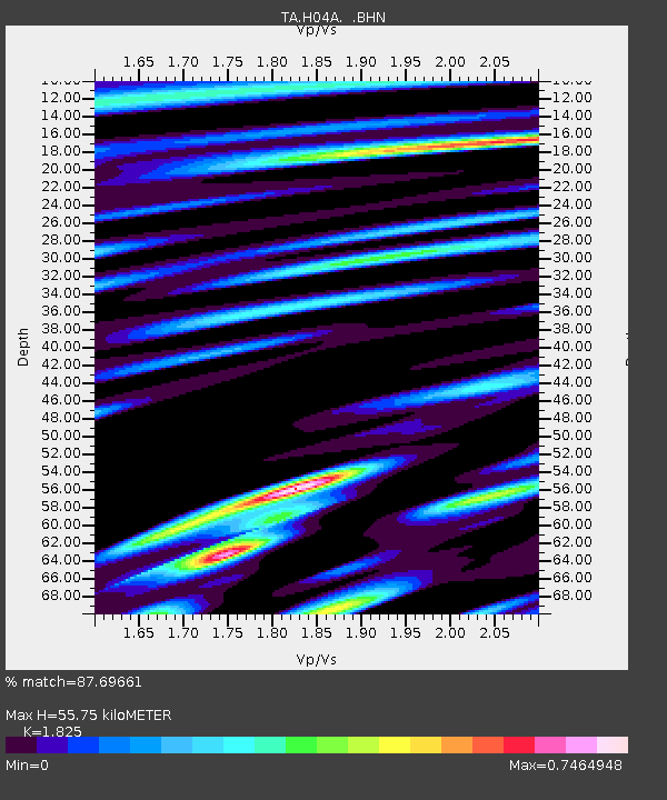
| Estimated Moho Depth: |
55.75 km |
| Estimated Crust Vp/Vs: |
1.83 |
| Assumed Crust Vp: |
6.566 km/s |
| Estimated Crust Vs: |
3.598 km/s |
| Estimated Crust Poisson's Ratio: |
0.29 |
|
| Radial Match: |
87.69661 % |
| Radial Bump: |
400 |
| Transverse Match: |
77.29926 % |
| Transverse Bump: |
400 |
| SOD ConfigId: |
5423 |
| Insert Time: |
2010-03-07 02:07:21.600 +0000 |
| GWidth: |
2.5 |
| Max Bumps: |
400 |
| Tol: |
0.001 |
|

Signal To Noise
| Channel | StoN | STA | LTA |
| TA:H04A: :BHN:20060611T20:12:37.724001Z | 3.2949343 | 2.783063E-7 | 8.4464894E-8 |
| TA:H04A: :BHE:20060611T20:12:37.724001Z | 4.5885363 | 3.1354452E-7 | 6.833214E-8 |
| TA:H04A: :BHZ:20060611T20:12:37.724001Z | 11.471104 | 9.193905E-7 | 8.014839E-8 |
| Arrivals |
| Ps | 7.2 SECOND |
| PpPs | 23 SECOND |
| PsPs/PpSs | 30 SECOND |


