You are here: Home > Network List > TA - USArray Transportable Network (new EarthScope stations) Stations List
> Station H04A Detroit Lake, OR, USA > Earthquake Result Viewer
H04A Detroit Lake, OR, USA - Earthquake Result Viewer
| Earthquake location: |
Vanuatu Islands |
| Earthquake latitude/longitude: |
-18.9/169.0 |
| Earthquake time(UTC): |
2006/10/03 (276) 18:03:14 GMT |
| Earthquake Depth: |
171 km |
| Earthquake Magnitude: |
5.9 MB, 6.3 MW, 6.3 MW |
| Earthquake Catalog/Contributor: |
WHDF/NEIC |
|
| Network: |
TA USArray Transportable Network (new EarthScope stations) |
| Station: |
H04A Detroit Lake, OR, USA |
| Lat/Lon: |
44.68 N/122.19 W |
| Elevation: |
652 m |
|
| Distance: |
88.9 deg |
| Az: |
41.701 deg |
| Baz: |
242.014 deg |
| Ray Param: |
0.041851707 |
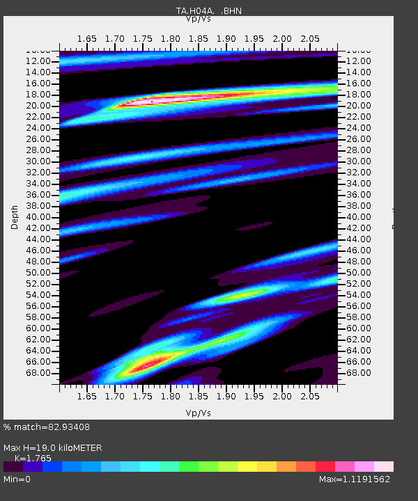
| Estimated Moho Depth: |
19.0 km |
| Estimated Crust Vp/Vs: |
1.76 |
| Assumed Crust Vp: |
6.566 km/s |
| Estimated Crust Vs: |
3.72 km/s |
| Estimated Crust Poisson's Ratio: |
0.26 |
|
| Radial Match: |
82.93408 % |
| Radial Bump: |
400 |
| Transverse Match: |
76.87197 % |
| Transverse Bump: |
400 |
| SOD ConfigId: |
2665 |
| Insert Time: |
2010-03-07 02:07:25.294 +0000 |
| GWidth: |
2.5 |
| Max Bumps: |
400 |
| Tol: |
0.001 |
|

Signal To Noise
| Channel | StoN | STA | LTA |
| TA:H04A: :BHN:20061003T18:15:18.298018Z | 1.9974736 | 1.8697153E-7 | 9.360401E-8 |
| TA:H04A: :BHE:20061003T18:15:18.298018Z | 4.882384 | 4.0828047E-7 | 8.3623185E-8 |
| TA:H04A: :BHZ:20061003T18:15:18.298018Z | 10.054127 | 1.400364E-6 | 1.3928252E-7 |
| Arrivals |
| Ps | 2.3 SECOND |
| PpPs | 7.8 SECOND |
| PsPs/PpSs | 10 SECOND |


