You are here: Home > Network List > TA - USArray Transportable Network (new EarthScope stations) Stations List
> Station H04A Detroit Lake, OR, USA > Earthquake Result Viewer
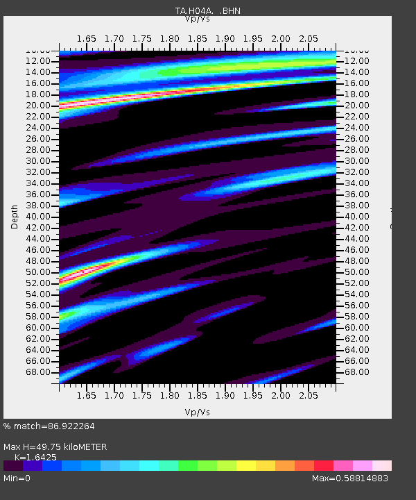
H04A Detroit Lake, OR, USA - Earthquake Result Viewer
| Earthquake location: |
Guerrero, Mexico |
| Earthquake latitude/longitude: |
18.6/-101.1 |
| Earthquake time(UTC): |
2006/08/11 (223) 14:30:40 GMT |
| Earthquake Depth: |
60 km |
| Earthquake Magnitude: |
6.0 MB, 6.1 MW, 6.0 MW |
| Earthquake Catalog/Contributor: |
WHDF/NEIC |
|
| Network: |
TA USArray Transportable Network (new EarthScope stations) |
| Station: |
H04A Detroit Lake, OR, USA |
| Lat/Lon: |
44.68 N/122.19 W |
| Elevation: |
652 m |
|
| Distance: |
31.5 deg |
| Az: |
330.491 deg |
| Baz: |
139.08 deg |
| Ray Param: |
0.07893079 |
| Estimated Moho Depth: |
49.75 km |
| Estimated Crust Vp/Vs: |
1.64 |
| Assumed Crust Vp: |
6.566 km/s |
| Estimated Crust Vs: |
3.998 km/s |
| Estimated Crust Poisson's Ratio: |
0.21 |
|
| Radial Match: |
86.922264 % |
| Radial Bump: |
400 |
| Transverse Match: |
66.80662 % |
| Transverse Bump: |
400 |
| SOD ConfigId: |
2665 |
| Insert Time: |
2010-03-07 02:07:36.271 +0000 |
| GWidth: |
2.5 |
| Max Bumps: |
400 |
| Tol: |
0.001 |
|

Signal To Noise
| Channel | StoN | STA | LTA |
| TA:H04A: :BHN:20060811T14:36:26.324012Z | 3.5473852 | 5.420061E-7 | 1.527903E-7 |
| TA:H04A: :BHE:20060811T14:36:26.324012Z | 3.2092211 | 2.6240244E-7 | 8.1765144E-8 |
| TA:H04A: :BHZ:20060811T14:36:26.324012Z | 11.621768 | 9.816556E-7 | 8.4466976E-8 |
| Arrivals |
| Ps | 5.3 SECOND |
| PpPs | 18 SECOND |
| PsPs/PpSs | 24 SECOND |


