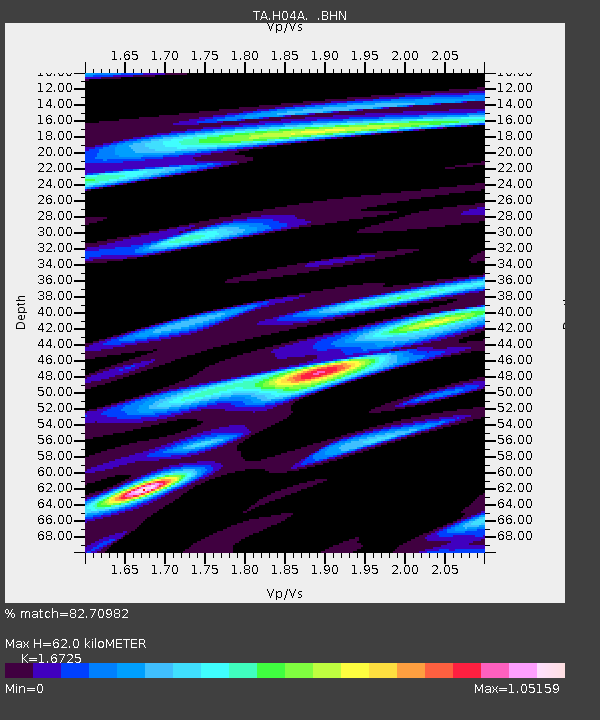
H04A Detroit Lake, OR, USA - Earthquake Result Viewer

Earthquake location: Rat Islands, Aleutian Islands
Earthquake latitude/longitude: 52.2/176.2
Earthquake time(UTC): 2006/06/27 (178) 02:39:35 GMT
Earthquake Depth: 34 km
Earthquake Magnitude: 5.6 MB, 6.0 MS, 6.2 MW, 6.2 MW
Earthquake Catalog/Contributor: WHDF/NEIC
Network: TA USArray Transportable Network (new EarthScope stations)
Station: H04A Detroit Lake, OR, USA
Lat/Lon: 44.68 N/122.19 W
Elevation: 652 m
Distance: 40.5 deg
Az: 75.348 deg
Baz: 303.422 deg
Ray Param: 0.07432968
Estimated Moho Depth: 62.0 km
Estimated Crust Vp/Vs: 1.67
Assumed Crust Vp: 6.566 km/s
Estimated Crust Vs: 3.926 km/s
Estimated Crust Poisson's Ratio: 0.22
Radial Match: 82.70982 %
Radial Bump: 384
Transverse Match: 65.88019 %
Transverse Bump: 400
SOD ConfigId: 2665
Insert Time: 2010-03-07 02:07:47.905 +0000
GWidth: 2.5
Max Bumps: 400
Tol: 0.001

Signal To Noise

ChannelStoNSTALTA
TA:H04A: :BHN:20060627T02:46:40.073009Z2.02861382.5868096E-71.275161E-7
TA:H04A: :BHE:20060627T02:46:40.073009Z1.93209094.5146476E-72.3366641E-7
TA:H04A: :BHZ:20060627T02:46:40.073009Z2.2176086.878682E-73.1018476E-7
Arrivals
Ps6.9 SECOND
PpPs23 SECOND
PsPs/PpSs30 SECOND