You are here: Home > Network List > TA - USArray Transportable Network (new EarthScope stations) Stations List
> Station H31M Peel River, Yukon, CAN > Earthquake Result Viewer
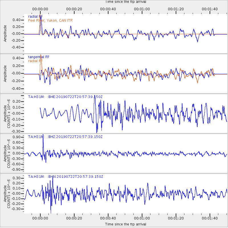
H31M Peel River, Yukon, CAN - Earthquake Result Viewer
*The percent match for this event was below the threshold and hence no stack was calculated.
| Earthquake location: |
Northeast Of Taiwan |
| Earthquake latitude/longitude: |
25.3/124.4 |
| Earthquake time(UTC): |
2019/07/22 (203) 20:46:58 GMT |
| Earthquake Depth: |
100 km |
| Earthquake Magnitude: |
5.1 Mww |
| Earthquake Catalog/Contributor: |
NEIC PDE/us |
|
| Network: |
TA USArray Transportable Network (new EarthScope stations) |
| Station: |
H31M Peel River, Yukon, CAN |
| Lat/Lon: |
65.81 N/134.34 W |
| Elevation: |
642 m |
|
| Distance: |
71.7 deg |
| Az: |
25.19 deg |
| Baz: |
290.751 deg |
| Ray Param: |
$rayparam |
*The percent match for this event was below the threshold and hence was not used in the summary stack. |
|
| Radial Match: |
61.594593 % |
| Radial Bump: |
400 |
| Transverse Match: |
50.53632 % |
| Transverse Bump: |
400 |
| SOD ConfigId: |
19053131 |
| Insert Time: |
2019-08-05 20:53:28.181 +0000 |
| GWidth: |
2.5 |
| Max Bumps: |
400 |
| Tol: |
0.001 |
|
Signal To Noise
| Channel | StoN | STA | LTA |
| TA:H31M: :BHZ:20190722T20:57:39.150Z | 4.0236077 | 2.7334374E-7 | 6.7934984E-8 |
| TA:H31M: :BHN:20190722T20:57:39.150Z | 1.8676952 | 9.276566E-8 | 4.966852E-8 |
| TA:H31M: :BHE:20190722T20:57:39.150Z | 2.4057114 | 1.6164084E-7 | 6.7190456E-8 |
| Arrivals |
| Ps | |
| PpPs | |
| PsPs/PpSs | |


