You are here: Home > Network List > TA - USArray Transportable Network (new EarthScope stations) Stations List
> Station I30M Mount Dempster, Yukon, CAN > Earthquake Result Viewer
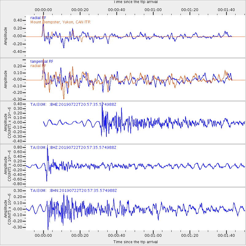
I30M Mount Dempster, Yukon, CAN - Earthquake Result Viewer
*The percent match for this event was below the threshold and hence no stack was calculated.
| Earthquake location: |
Northeast Of Taiwan |
| Earthquake latitude/longitude: |
25.3/124.4 |
| Earthquake time(UTC): |
2019/07/22 (203) 20:46:58 GMT |
| Earthquake Depth: |
100 km |
| Earthquake Magnitude: |
5.1 Mww |
| Earthquake Catalog/Contributor: |
NEIC PDE/us |
|
| Network: |
TA USArray Transportable Network (new EarthScope stations) |
| Station: |
I30M Mount Dempster, Yukon, CAN |
| Lat/Lon: |
65.22 N/136.38 W |
| Elevation: |
1399 m |
|
| Distance: |
71.1 deg |
| Az: |
26.075 deg |
| Baz: |
289.184 deg |
| Ray Param: |
$rayparam |
*The percent match for this event was below the threshold and hence was not used in the summary stack. |
|
| Radial Match: |
57.49104 % |
| Radial Bump: |
400 |
| Transverse Match: |
61.640472 % |
| Transverse Bump: |
400 |
| SOD ConfigId: |
19053131 |
| Insert Time: |
2019-08-05 20:53:33.814 +0000 |
| GWidth: |
2.5 |
| Max Bumps: |
400 |
| Tol: |
0.001 |
|
Signal To Noise
| Channel | StoN | STA | LTA |
| TA:I30M: :BHZ:20190722T20:57:35.574988Z | 6.850433 | 2.6013885E-7 | 3.7974075E-8 |
| TA:I30M: :BHN:20190722T20:57:35.574988Z | 3.9520402 | 1.05120435E-7 | 2.659903E-8 |
| TA:I30M: :BHE:20190722T20:57:35.574988Z | 3.8611352 | 1.3538633E-7 | 3.5063866E-8 |
| Arrivals |
| Ps | |
| PpPs | |
| PsPs/PpSs | |


