You are here: Home > Network List > TA - USArray Transportable Network (new EarthScope stations) Stations List
> Station U10A Ash Meadows, Armagosa NV, USA > Earthquake Result Viewer
U10A Ash Meadows, Armagosa NV, USA - Earthquake Result Viewer

| Earthquake location: |
Peru-Ecuador Border Region |
| Earthquake latitude/longitude: |
-2.3/-77.8 |
| Earthquake time(UTC): |
2007/11/16 (320) 03:13:00 GMT |
| Earthquake Depth: |
123 km |
| Earthquake Magnitude: |
6.3 MB, 6.8 MW, 6.7 MW |
| Earthquake Catalog/Contributor: |
WHDF/NEIC |
|
| Network: |
TA USArray Transportable Network (new EarthScope stations) |
| Station: |
U10A Ash Meadows, Armagosa NV, USA |
| Lat/Lon: |
36.42 N/116.33 W |
| Elevation: |
668 m |
|
| Distance: |
52.6 deg |
| Az: |
320.818 deg |
| Baz: |
128.496 deg |
| Ray Param: |
0.06623701 |
| Estimated Moho Depth: |
29.0 km |
| Estimated Crust Vp/Vs: |
1.90 |
| Assumed Crust Vp: |
6.279 km/s |
| Estimated Crust Vs: |
3.3 km/s |
| Estimated Crust Poisson's Ratio: |
0.31 |
|
| Radial Match: |
93.673965 % |
| Radial Bump: |
400 |
| Transverse Match: |
77.481255 % |
| Transverse Bump: |
400 |
| SOD ConfigId: |
2564 |
| Insert Time: |
2010-03-07 02:08:46.517 +0000 |
| GWidth: |
2.5 |
| Max Bumps: |
400 |
| Tol: |
0.001 |
|
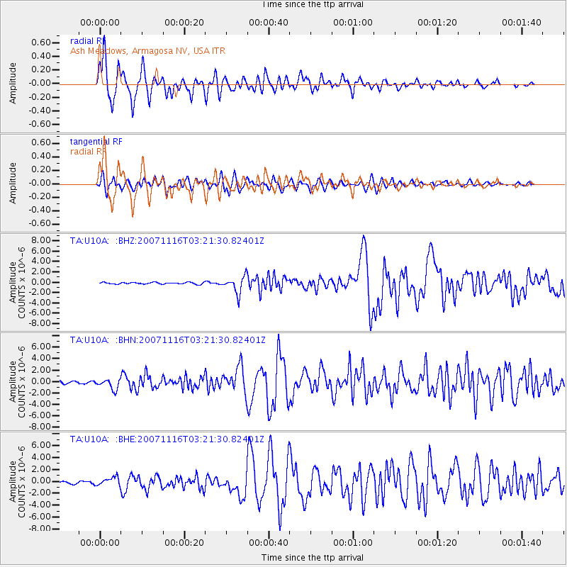
Signal To Noise
| Channel | StoN | STA | LTA |
| TA:U10A: :BHN:20071116T03:21:30.82401Z | 2.6236196 | 9.076085E-7 | 3.4593756E-7 |
| TA:U10A: :BHE:20071116T03:21:30.82401Z | 2.3764298 | 7.356107E-7 | 3.0954448E-7 |
| TA:U10A: :BHZ:20071116T03:21:30.82401Z | 10.085929 | 1.6579426E-6 | 1.6438173E-7 |
| Arrivals |
| Ps | 4.4 SECOND |
| PpPs | 13 SECOND |
| PsPs/PpSs | 17 SECOND |


