You are here: Home > Network List > TA - USArray Transportable Network (new EarthScope stations) Stations List
> Station U10A Ash Meadows, Armagosa NV, USA > Earthquake Result Viewer
U10A Ash Meadows, Armagosa NV, USA - Earthquake Result Viewer

| Earthquake location: |
South Of Mariana Islands |
| Earthquake latitude/longitude: |
10.5/145.7 |
| Earthquake time(UTC): |
2007/09/30 (273) 02:08:30 GMT |
| Earthquake Depth: |
14 km |
| Earthquake Magnitude: |
6.4 MB, 7.1 MS, 6.9 MW, 6.9 MW |
| Earthquake Catalog/Contributor: |
WHDF/NEIC |
|
| Network: |
TA USArray Transportable Network (new EarthScope stations) |
| Station: |
U10A Ash Meadows, Armagosa NV, USA |
| Lat/Lon: |
36.42 N/116.33 W |
| Elevation: |
668 m |
|
| Distance: |
90.2 deg |
| Az: |
53.02 deg |
| Baz: |
283.053 deg |
| Ray Param: |
0.041690882 |
| Estimated Moho Depth: |
10.75 km |
| Estimated Crust Vp/Vs: |
1.61 |
| Assumed Crust Vp: |
6.279 km/s |
| Estimated Crust Vs: |
3.912 km/s |
| Estimated Crust Poisson's Ratio: |
0.18 |
|
| Radial Match: |
87.68791 % |
| Radial Bump: |
400 |
| Transverse Match: |
78.36897 % |
| Transverse Bump: |
400 |
| SOD ConfigId: |
2564 |
| Insert Time: |
2010-03-07 02:08:52.817 +0000 |
| GWidth: |
2.5 |
| Max Bumps: |
400 |
| Tol: |
0.001 |
|
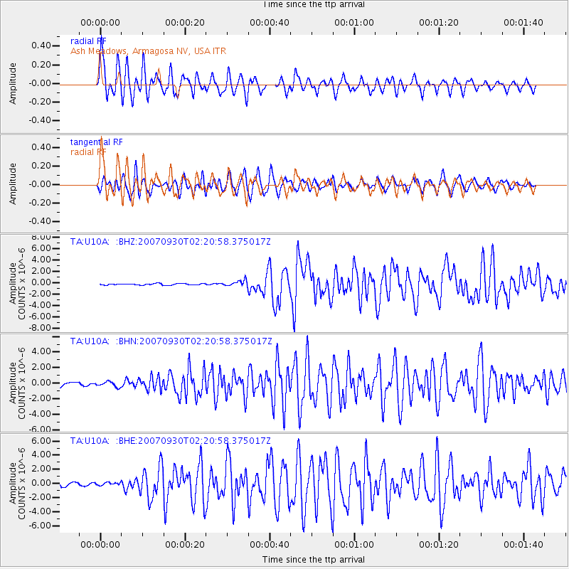
Signal To Noise
| Channel | StoN | STA | LTA |
| TA:U10A: :BHN:20070930T02:20:58.375017Z | 1.0970886 | 3.296136E-7 | 3.0044393E-7 |
| TA:U10A: :BHE:20070930T02:20:58.375017Z | 0.617072 | 1.9436403E-7 | 3.1497788E-7 |
| TA:U10A: :BHZ:20070930T02:20:58.375017Z | 3.9381957 | 5.123085E-7 | 1.3008712E-7 |
| Arrivals |
| Ps | 1.1 SECOND |
| PpPs | 4.4 SECOND |
| PsPs/PpSs | 5.4 SECOND |


