You are here: Home > Network List > TA - USArray Transportable Network (new EarthScope stations) Stations List
> Station U10A Ash Meadows, Armagosa NV, USA > Earthquake Result Viewer
U10A Ash Meadows, Armagosa NV, USA - Earthquake Result Viewer
| Earthquake location: |
Jujuy Province, Argentina |
| Earthquake latitude/longitude: |
-22.2/-65.8 |
| Earthquake time(UTC): |
2007/07/21 (202) 15:34:52 GMT |
| Earthquake Depth: |
290 km |
| Earthquake Magnitude: |
5.8 MB, 6.4 MW, 6.3 MW |
| Earthquake Catalog/Contributor: |
WHDF/NEIC |
|
| Network: |
TA USArray Transportable Network (new EarthScope stations) |
| Station: |
U10A Ash Meadows, Armagosa NV, USA |
| Lat/Lon: |
36.42 N/116.33 W |
| Elevation: |
668 m |
|
| Distance: |
75.3 deg |
| Az: |
319.917 deg |
| Baz: |
132.262 deg |
| Ray Param: |
0.050946638 |
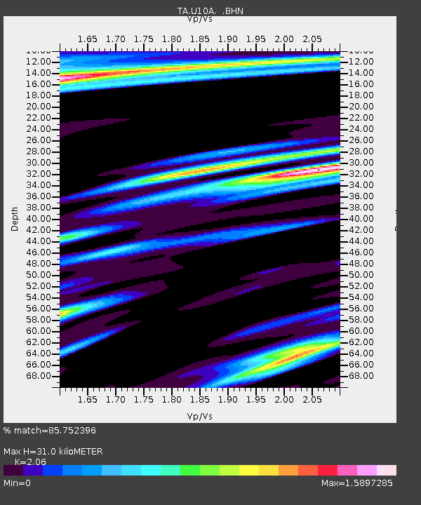
| Estimated Moho Depth: |
31.0 km |
| Estimated Crust Vp/Vs: |
2.06 |
| Assumed Crust Vp: |
6.279 km/s |
| Estimated Crust Vs: |
3.048 km/s |
| Estimated Crust Poisson's Ratio: |
0.35 |
|
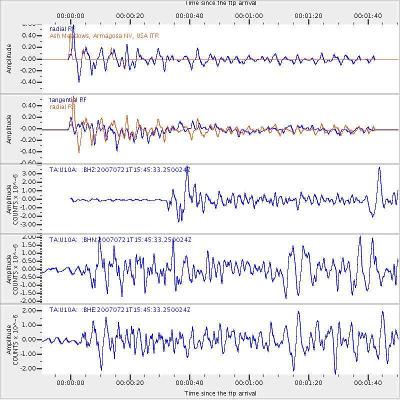
| Radial Match: |
85.752396 % |
| Radial Bump: |
400 |
| Transverse Match: |
76.2842 % |
| Transverse Bump: |
400 |
| SOD ConfigId: |
2564 |
| Insert Time: |
2010-03-07 02:09:08.752 +0000 |
| GWidth: |
2.5 |
| Max Bumps: |
400 |
| Tol: |
0.001 |
|
Signal To Noise
| Channel | StoN | STA | LTA |
| TA:U10A: :BHN:20070721T15:45:33.250024Z | 1.3714613 | 1.8270288E-7 | 1.3321768E-7 |
| TA:U10A: :BHE:20070721T15:45:33.250024Z | 1.0540433 | 1.9709647E-7 | 1.8699087E-7 |
| TA:U10A: :BHZ:20070721T15:45:33.250024Z | 6.1284037 | 4.940738E-7 | 8.062031E-8 |
| Arrivals |
| Ps | 5.4 SECOND |
| PpPs | 15 SECOND |
| PsPs/PpSs | 20 SECOND |


