You are here: Home > Network List > TA - USArray Transportable Network (new EarthScope stations) Stations List
> Station U10A Ash Meadows, Armagosa NV, USA > Earthquake Result Viewer
U10A Ash Meadows, Armagosa NV, USA - Earthquake Result Viewer

| Earthquake location: |
Vanuatu Islands |
| Earthquake latitude/longitude: |
-15.4/168.6 |
| Earthquake time(UTC): |
2007/07/15 (196) 09:27:34 GMT |
| Earthquake Depth: |
8.0 km |
| Earthquake Magnitude: |
6.0 MB, 5.8 MS, 6.1 MW, 6.0 MW |
| Earthquake Catalog/Contributor: |
WHDF/NEIC |
|
| Network: |
TA USArray Transportable Network (new EarthScope stations) |
| Station: |
U10A Ash Meadows, Armagosa NV, USA |
| Lat/Lon: |
36.42 N/116.33 W |
| Elevation: |
668 m |
|
| Distance: |
87.4 deg |
| Az: |
51.274 deg |
| Baz: |
248.908 deg |
| Ray Param: |
0.043324266 |
| Estimated Moho Depth: |
10.0 km |
| Estimated Crust Vp/Vs: |
1.70 |
| Assumed Crust Vp: |
6.279 km/s |
| Estimated Crust Vs: |
3.704 km/s |
| Estimated Crust Poisson's Ratio: |
0.23 |
|
| Radial Match: |
90.26881 % |
| Radial Bump: |
400 |
| Transverse Match: |
86.91171 % |
| Transverse Bump: |
367 |
| SOD ConfigId: |
2564 |
| Insert Time: |
2010-03-07 02:09:16.648 +0000 |
| GWidth: |
2.5 |
| Max Bumps: |
400 |
| Tol: |
0.001 |
|
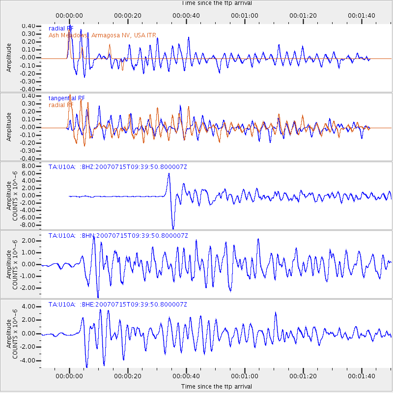
Signal To Noise
| Channel | StoN | STA | LTA |
| TA:U10A: :BHN:20070715T09:39:50.800007Z | 3.7316709 | 3.0309945E-7 | 8.1223526E-8 |
| TA:U10A: :BHE:20070715T09:39:50.800007Z | 7.2180667 | 8.68809E-7 | 1.203659E-7 |
| TA:U10A: :BHZ:20070715T09:39:50.800007Z | 30.486794 | 2.2132353E-6 | 7.259653E-8 |
| Arrivals |
| Ps | 1.1 SECOND |
| PpPs | 4.2 SECOND |
| PsPs/PpSs | 5.3 SECOND |


