You are here: Home > Network List > TA - USArray Transportable Network (new EarthScope stations) Stations List
> Station P17K Kvichak River, AK, USA > Earthquake Result Viewer
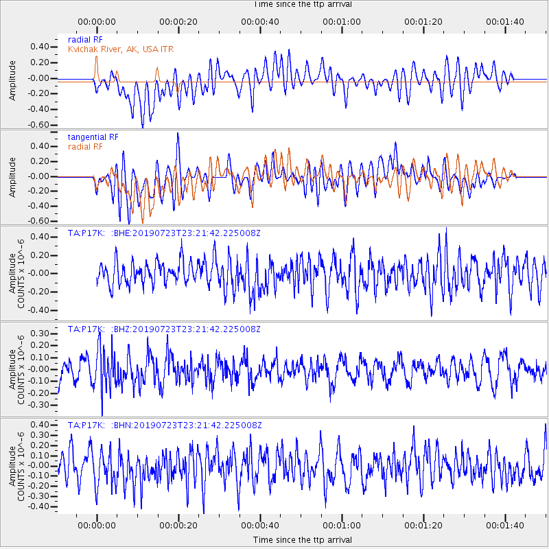
P17K Kvichak River, AK, USA - Earthquake Result Viewer
*The percent match for this event was below the threshold and hence no stack was calculated.
| Earthquake location: |
South Of Kermadec Islands |
| Earthquake latitude/longitude: |
-33.8/-179.5 |
| Earthquake time(UTC): |
2019/07/23 (204) 23:08:52 GMT |
| Earthquake Depth: |
10 km |
| Earthquake Magnitude: |
5.5 Mww |
| Earthquake Catalog/Contributor: |
NEIC PDE/us |
|
| Network: |
TA USArray Transportable Network (new EarthScope stations) |
| Station: |
P17K Kvichak River, AK, USA |
| Lat/Lon: |
59.20 N/156.44 W |
| Elevation: |
91 m |
|
| Distance: |
94.6 deg |
| Az: |
11.674 deg |
| Baz: |
199.107 deg |
| Ray Param: |
$rayparam |
*The percent match for this event was below the threshold and hence was not used in the summary stack. |
|
| Radial Match: |
42.147 % |
| Radial Bump: |
400 |
| Transverse Match: |
54.432964 % |
| Transverse Bump: |
400 |
| SOD ConfigId: |
19053131 |
| Insert Time: |
2019-08-06 23:12:53.194 +0000 |
| GWidth: |
2.5 |
| Max Bumps: |
400 |
| Tol: |
0.001 |
|
Signal To Noise
| Channel | StoN | STA | LTA |
| TA:P17K: :BHZ:20190723T23:21:42.225008Z | 1.8984104 | 1.6919061E-7 | 8.912225E-8 |
| TA:P17K: :BHN:20190723T23:21:42.225008Z | 1.4787799 | 1.7821385E-7 | 1.2051412E-7 |
| TA:P17K: :BHE:20190723T23:21:42.225008Z | 1.5126134 | 1.735882E-7 | 1.1476046E-7 |
| Arrivals |
| Ps | |
| PpPs | |
| PsPs/PpSs | |


