You are here: Home > Network List > US - United States National Seismic Network Stations List
> Station MNTX Cornudas Mountains, Texas, USA > Earthquake Result Viewer
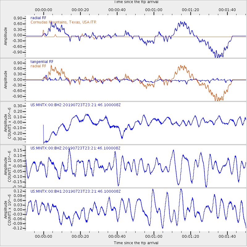
MNTX Cornudas Mountains, Texas, USA - Earthquake Result Viewer
*The percent match for this event was below the threshold and hence no stack was calculated.
| Earthquake location: |
South Of Kermadec Islands |
| Earthquake latitude/longitude: |
-33.8/-179.5 |
| Earthquake time(UTC): |
2019/07/23 (204) 23:08:52 GMT |
| Earthquake Depth: |
10 km |
| Earthquake Magnitude: |
5.5 Mww |
| Earthquake Catalog/Contributor: |
NEIC PDE/us |
|
| Network: |
US United States National Seismic Network |
| Station: |
MNTX Cornudas Mountains, Texas, USA |
| Lat/Lon: |
31.70 N/105.38 W |
| Elevation: |
404 m |
|
| Distance: |
95.5 deg |
| Az: |
55.455 deg |
| Baz: |
233.561 deg |
| Ray Param: |
$rayparam |
*The percent match for this event was below the threshold and hence was not used in the summary stack. |
|
| Radial Match: |
33.28342 % |
| Radial Bump: |
400 |
| Transverse Match: |
47.298546 % |
| Transverse Bump: |
400 |
| SOD ConfigId: |
19053131 |
| Insert Time: |
2019-08-06 23:13:23.429 +0000 |
| GWidth: |
2.5 |
| Max Bumps: |
400 |
| Tol: |
0.001 |
|
Signal To Noise
| Channel | StoN | STA | LTA |
| US:MNTX:00:BHZ:20190723T23:21:46.100008Z | 0.66617763 | 5.4722612E-8 | 8.2144176E-8 |
| US:MNTX:00:BH1:20190723T23:21:46.100008Z | 0.6354812 | 2.725819E-8 | 4.2893777E-8 |
| US:MNTX:00:BH2:20190723T23:21:46.100008Z | 0.7697829 | 1.2086588E-7 | 1.5701293E-7 |
| Arrivals |
| Ps | |
| PpPs | |
| PsPs/PpSs | |


