You are here: Home > Network List > TA - USArray Transportable Network (new EarthScope stations) Stations List
> Station U10A Ash Meadows, Armagosa NV, USA > Earthquake Result Viewer
U10A Ash Meadows, Armagosa NV, USA - Earthquake Result Viewer

| Earthquake location: |
Kuril Islands |
| Earthquake latitude/longitude: |
46.4/153.2 |
| Earthquake time(UTC): |
2008/03/03 (063) 09:31:02 GMT |
| Earthquake Depth: |
10 km |
| Earthquake Magnitude: |
6.2 MB, 6.5 MS, 6.5 MW, 6.5 MW |
| Earthquake Catalog/Contributor: |
WHDF/NEIC |
|
| Network: |
TA USArray Transportable Network (new EarthScope stations) |
| Station: |
U10A Ash Meadows, Armagosa NV, USA |
| Lat/Lon: |
36.42 N/116.33 W |
| Elevation: |
668 m |
|
| Distance: |
65.0 deg |
| Az: |
62.826 deg |
| Baz: |
310.253 deg |
| Ray Param: |
0.05853019 |
| Estimated Moho Depth: |
29.5 km |
| Estimated Crust Vp/Vs: |
1.99 |
| Assumed Crust Vp: |
6.279 km/s |
| Estimated Crust Vs: |
3.159 km/s |
| Estimated Crust Poisson's Ratio: |
0.33 |
|
| Radial Match: |
87.29639 % |
| Radial Bump: |
400 |
| Transverse Match: |
71.11108 % |
| Transverse Bump: |
400 |
| SOD ConfigId: |
2564 |
| Insert Time: |
2010-03-07 02:09:56.987 +0000 |
| GWidth: |
2.5 |
| Max Bumps: |
400 |
| Tol: |
0.001 |
|
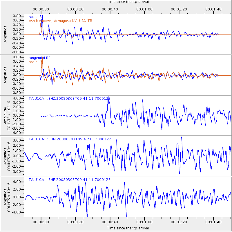
Signal To Noise
| Channel | StoN | STA | LTA |
| TA:U10A: :BHN:20080303T09:41:11.700012Z | 0.91134566 | 3.8967184E-7 | 4.2757856E-7 |
| TA:U10A: :BHE:20080303T09:41:11.700012Z | 1.1357316 | 3.631652E-7 | 3.1976322E-7 |
| TA:U10A: :BHZ:20080303T09:41:11.700012Z | 3.6981785 | 5.742597E-7 | 1.5528175E-7 |
| Arrivals |
| Ps | 4.8 SECOND |
| PpPs | 14 SECOND |
| PsPs/PpSs | 18 SECOND |


