You are here: Home > Network List > TA - USArray Transportable Network (new EarthScope stations) Stations List
> Station F06A Goldendale, WA, USA > Earthquake Result Viewer
F06A Goldendale, WA, USA - Earthquake Result Viewer
| Earthquake location: |
South Of Mariana Islands |
| Earthquake latitude/longitude: |
10.5/145.7 |
| Earthquake time(UTC): |
2007/09/30 (273) 02:08:30 GMT |
| Earthquake Depth: |
14 km |
| Earthquake Magnitude: |
6.4 MB, 7.1 MS, 6.9 MW, 6.9 MW |
| Earthquake Catalog/Contributor: |
WHDF/NEIC |
|
| Network: |
TA USArray Transportable Network (new EarthScope stations) |
| Station: |
F06A Goldendale, WA, USA |
| Lat/Lon: |
45.77 N/120.78 W |
| Elevation: |
577 m |
|
| Distance: |
85.0 deg |
| Az: |
44.533 deg |
| Baz: |
279.771 deg |
| Ray Param: |
0.04505345 |
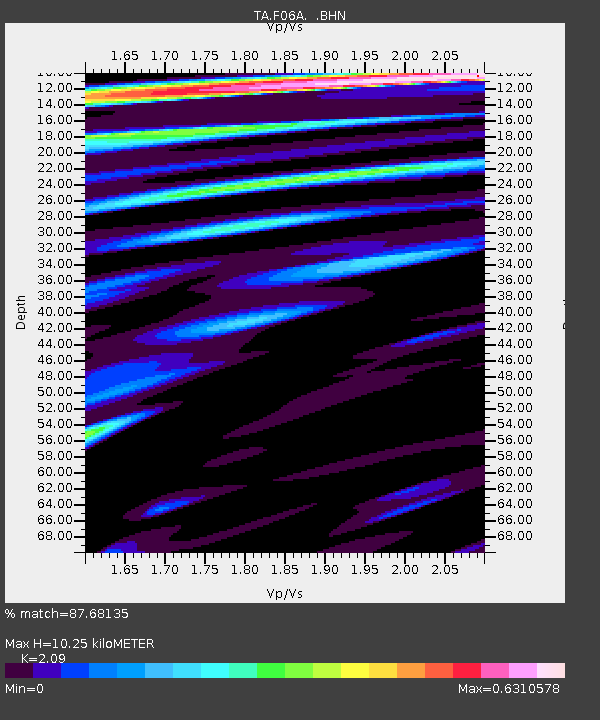
| Estimated Moho Depth: |
10.25 km |
| Estimated Crust Vp/Vs: |
2.09 |
| Assumed Crust Vp: |
6.597 km/s |
| Estimated Crust Vs: |
3.157 km/s |
| Estimated Crust Poisson's Ratio: |
0.35 |
|
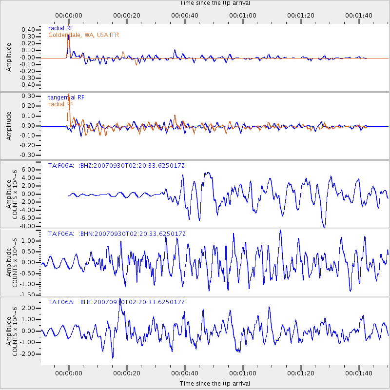
| Radial Match: |
87.68135 % |
| Radial Bump: |
400 |
| Transverse Match: |
77.672554 % |
| Transverse Bump: |
400 |
| SOD ConfigId: |
2564 |
| Insert Time: |
2010-03-07 02:10:09.915 +0000 |
| GWidth: |
2.5 |
| Max Bumps: |
400 |
| Tol: |
0.001 |
|
Signal To Noise
| Channel | StoN | STA | LTA |
| TA:F06A: :BHN:20070930T02:20:33.625017Z | 1.2180351 | 2.2860115E-7 | 1.8768027E-7 |
| TA:F06A: :BHE:20070930T02:20:33.625017Z | 1.9696673 | 4.2194873E-7 | 2.1422335E-7 |
| TA:F06A: :BHZ:20070930T02:20:33.625017Z | 1.886802 | 6.114211E-7 | 3.2405154E-7 |
| Arrivals |
| Ps | 1.7 SECOND |
| PpPs | 4.7 SECOND |
| PsPs/PpSs | 6.4 SECOND |


