You are here: Home > Network List > US - United States National Seismic Network Stations List
> Station MSO Missoula, Montana, USA > Earthquake Result Viewer
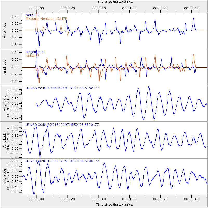
MSO Missoula, Montana, USA - Earthquake Result Viewer
*The percent match for this event was below the threshold and hence no stack was calculated.
| Earthquake location: |
Near East Coast Of Honshu, Japan |
| Earthquake latitude/longitude: |
37.5/141.5 |
| Earthquake time(UTC): |
2016/12/19 (354) 16:41:14 GMT |
| Earthquake Depth: |
27 km |
| Earthquake Magnitude: |
5.5 mb |
| Earthquake Catalog/Contributor: |
NEIC PDE/us |
|
| Network: |
US United States National Seismic Network |
| Station: |
MSO Missoula, Montana, USA |
| Lat/Lon: |
46.83 N/113.94 W |
| Elevation: |
1264 m |
|
| Distance: |
72.4 deg |
| Az: |
44.209 deg |
| Baz: |
306.083 deg |
| Ray Param: |
$rayparam |
*The percent match for this event was below the threshold and hence was not used in the summary stack. |
|
| Radial Match: |
72.21173 % |
| Radial Bump: |
302 |
| Transverse Match: |
66.71015 % |
| Transverse Bump: |
400 |
| SOD ConfigId: |
1894071 |
| Insert Time: |
2017-01-02 16:46:10.221 +0000 |
| GWidth: |
2.5 |
| Max Bumps: |
400 |
| Tol: |
0.001 |
|
Signal To Noise
| Channel | StoN | STA | LTA |
| US:MSO:00:BHZ:20161219T16:52:06.650017Z | 1.1838391 | 6.99032E-7 | 5.9047886E-7 |
| US:MSO:00:BH1:20161219T16:52:06.650017Z | 2.1211858 | 6.418948E-7 | 3.026113E-7 |
| US:MSO:00:BH2:20161219T16:52:06.650017Z | 2.5654423 | 9.97319E-7 | 3.8875126E-7 |
| Arrivals |
| Ps | |
| PpPs | |
| PsPs/PpSs | |


