You are here: Home > Network List > TA - USArray Transportable Network (new EarthScope stations) Stations List
> Station F06A Goldendale, WA, USA > Earthquake Result Viewer
F06A Goldendale, WA, USA - Earthquake Result Viewer
| Earthquake location: |
Vanuatu Islands |
| Earthquake latitude/longitude: |
-15.6/167.7 |
| Earthquake time(UTC): |
2007/08/01 (213) 17:08:51 GMT |
| Earthquake Depth: |
120 km |
| Earthquake Magnitude: |
6.2 MB, 7.2 MW, 7.2 MW |
| Earthquake Catalog/Contributor: |
WHDF/NEIC |
|
| Network: |
TA USArray Transportable Network (new EarthScope stations) |
| Station: |
F06A Goldendale, WA, USA |
| Lat/Lon: |
45.77 N/120.78 W |
| Elevation: |
577 m |
|
| Distance: |
88.7 deg |
| Az: |
41.616 deg |
| Baz: |
246.106 deg |
| Ray Param: |
0.04214224 |
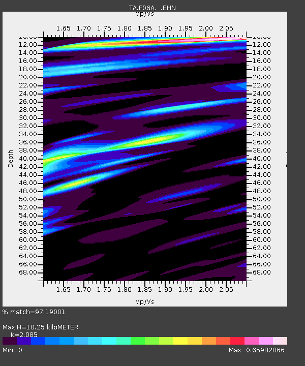
| Estimated Moho Depth: |
10.25 km |
| Estimated Crust Vp/Vs: |
2.09 |
| Assumed Crust Vp: |
6.597 km/s |
| Estimated Crust Vs: |
3.164 km/s |
| Estimated Crust Poisson's Ratio: |
0.35 |
|
| Radial Match: |
97.19001 % |
| Radial Bump: |
400 |
| Transverse Match: |
89.10979 % |
| Transverse Bump: |
392 |
| SOD ConfigId: |
2564 |
| Insert Time: |
2010-03-07 02:10:32.474 +0000 |
| GWidth: |
2.5 |
| Max Bumps: |
400 |
| Tol: |
0.001 |
|

Signal To Noise
| Channel | StoN | STA | LTA |
| TA:F06A: :BHN:20070801T17:21:00.050024Z | 1.9631444 | 1.18448774E-7 | 6.033625E-8 |
| TA:F06A: :BHE:20070801T17:21:00.050024Z | 2.4128613 | 2.092581E-7 | 8.672612E-8 |
| TA:F06A: :BHZ:20070801T17:21:00.050024Z | 7.582653 | 8.439245E-7 | 1.11296735E-7 |
| Arrivals |
| Ps | 1.7 SECOND |
| PpPs | 4.7 SECOND |
| PsPs/PpSs | 6.4 SECOND |


