You are here: Home > Network List > TA - USArray Transportable Network (new EarthScope stations) Stations List
> Station F06A Goldendale, WA, USA > Earthquake Result Viewer
F06A Goldendale, WA, USA - Earthquake Result Viewer
| Earthquake location: |
Solomon Islands |
| Earthquake latitude/longitude: |
-7.3/155.7 |
| Earthquake time(UTC): |
2007/04/01 (091) 21:11:33 GMT |
| Earthquake Depth: |
10 km |
| Earthquake Magnitude: |
6.3 MB |
| Earthquake Catalog/Contributor: |
WHDF/NEIC |
|
| Network: |
TA USArray Transportable Network (new EarthScope stations) |
| Station: |
F06A Goldendale, WA, USA |
| Lat/Lon: |
45.77 N/120.78 W |
| Elevation: |
577 m |
|
| Distance: |
90.6 deg |
| Az: |
44.067 deg |
| Baz: |
260.275 deg |
| Ray Param: |
0.041658267 |
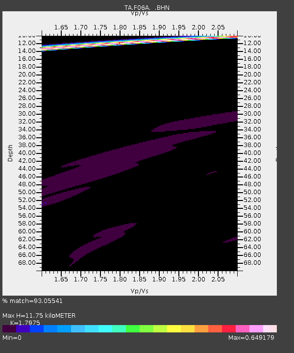
| Estimated Moho Depth: |
11.75 km |
| Estimated Crust Vp/Vs: |
1.80 |
| Assumed Crust Vp: |
6.597 km/s |
| Estimated Crust Vs: |
3.67 km/s |
| Estimated Crust Poisson's Ratio: |
0.28 |
|
| Radial Match: |
93.05541 % |
| Radial Bump: |
306 |
| Transverse Match: |
81.85462 % |
| Transverse Bump: |
223 |
| SOD ConfigId: |
2564 |
| Insert Time: |
2010-03-07 02:10:53.031 +0000 |
| GWidth: |
2.5 |
| Max Bumps: |
400 |
| Tol: |
0.001 |
|
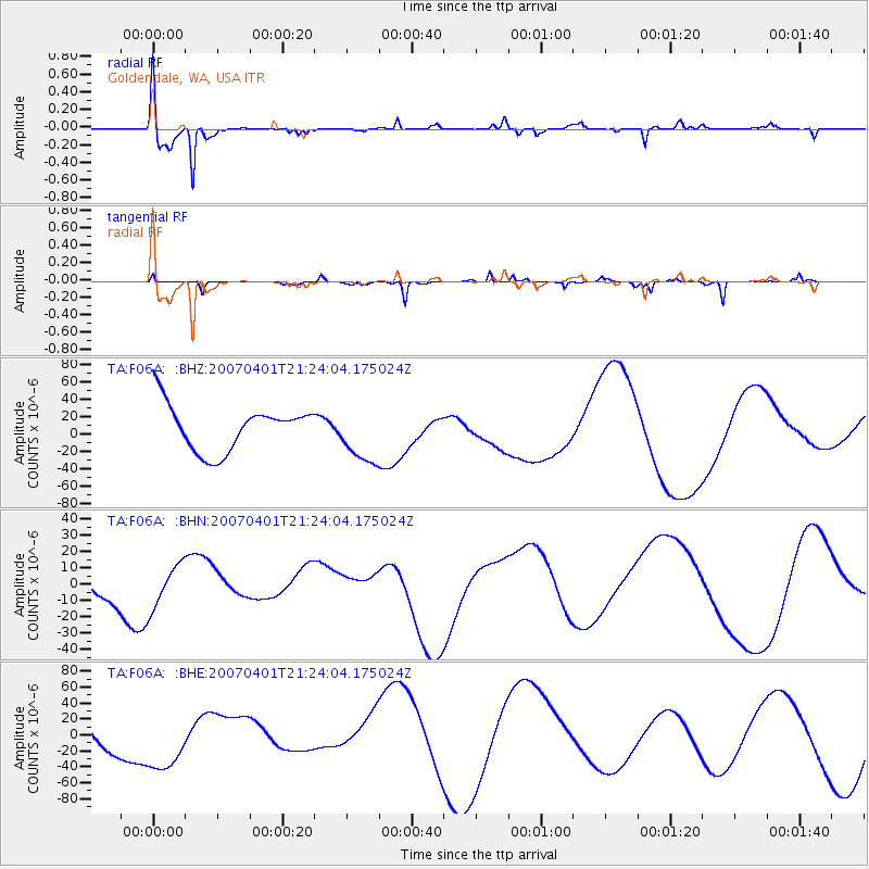
Signal To Noise
| Channel | StoN | STA | LTA |
| TA:F06A: :BHN:20070401T21:24:04.175024Z | 1.2365028 | 1.3103181E-5 | 1.0596969E-5 |
| TA:F06A: :BHE:20070401T21:24:04.175024Z | 1.163935 | 3.2539378E-5 | 2.7956354E-5 |
| TA:F06A: :BHZ:20070401T21:24:04.175024Z | 1.2691394 | 3.297878E-5 | 2.5985151E-5 |
| Arrivals |
| Ps | 1.5 SECOND |
| PpPs | 4.9 SECOND |
| PsPs/PpSs | 6.3 SECOND |


