You are here: Home > Network List > TA - USArray Transportable Network (new EarthScope stations) Stations List
> Station O18K Koktuh Hills, AK, USA > Earthquake Result Viewer
O18K Koktuh Hills, AK, USA - Earthquake Result Viewer
| Earthquake location: |
Philippine Islands Region |
| Earthquake latitude/longitude: |
20.8/121.9 |
| Earthquake time(UTC): |
2019/07/26 (207) 20:16:57 GMT |
| Earthquake Depth: |
9.1 km |
| Earthquake Magnitude: |
5.4 Mww |
| Earthquake Catalog/Contributor: |
NEIC PDE/us |
|
| Network: |
TA USArray Transportable Network (new EarthScope stations) |
| Station: |
O18K Koktuh Hills, AK, USA |
| Lat/Lon: |
59.85 N/155.21 W |
| Elevation: |
544 m |
|
| Distance: |
68.7 deg |
| Az: |
32.517 deg |
| Baz: |
274.846 deg |
| Ray Param: |
0.056123566 |
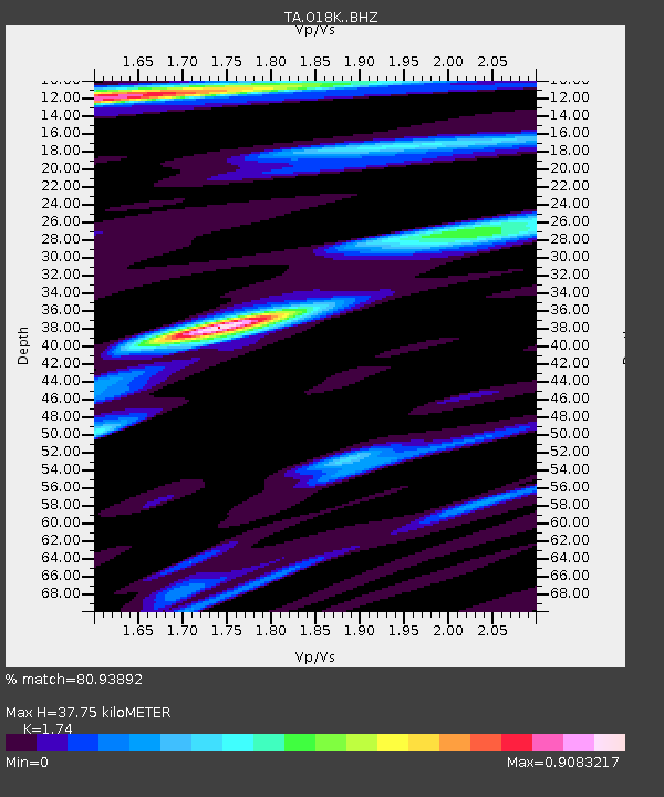
| Estimated Moho Depth: |
37.75 km |
| Estimated Crust Vp/Vs: |
1.74 |
| Assumed Crust Vp: |
6.438 km/s |
| Estimated Crust Vs: |
3.7 km/s |
| Estimated Crust Poisson's Ratio: |
0.25 |
|
| Radial Match: |
80.93892 % |
| Radial Bump: |
400 |
| Transverse Match: |
73.86901 % |
| Transverse Bump: |
400 |
| SOD ConfigId: |
19053131 |
| Insert Time: |
2019-08-09 20:22:32.494 +0000 |
| GWidth: |
2.5 |
| Max Bumps: |
400 |
| Tol: |
0.001 |
|

Signal To Noise
| Channel | StoN | STA | LTA |
| TA:O18K: :BHZ:20190726T20:27:29.82502Z | 2.3063903 | 2.402455E-7 | 1.0416515E-7 |
| TA:O18K: :BHN:20190726T20:27:29.82502Z | 1.2440625 | 9.613919E-8 | 7.727842E-8 |
| TA:O18K: :BHE:20190726T20:27:29.82502Z | 0.9310439 | 6.6655424E-8 | 7.159214E-8 |
| Arrivals |
| Ps | 4.5 SECOND |
| PpPs | 15 SECOND |
| PsPs/PpSs | 20 SECOND |


