You are here: Home > Network List > TA - USArray Transportable Network (new EarthScope stations) Stations List
> Station P17K Kvichak River, AK, USA > Earthquake Result Viewer
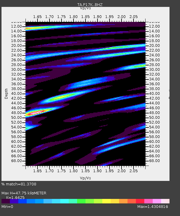
P17K Kvichak River, AK, USA - Earthquake Result Viewer
| Earthquake location: |
Philippine Islands Region |
| Earthquake latitude/longitude: |
20.8/121.9 |
| Earthquake time(UTC): |
2019/07/26 (207) 20:16:57 GMT |
| Earthquake Depth: |
9.1 km |
| Earthquake Magnitude: |
5.4 Mww |
| Earthquake Catalog/Contributor: |
NEIC PDE/us |
|
| Network: |
TA USArray Transportable Network (new EarthScope stations) |
| Station: |
P17K Kvichak River, AK, USA |
| Lat/Lon: |
59.20 N/156.44 W |
| Elevation: |
91 m |
|
| Distance: |
68.1 deg |
| Az: |
33.278 deg |
| Baz: |
274.066 deg |
| Ray Param: |
0.05649938 |
| Estimated Moho Depth: |
47.75 km |
| Estimated Crust Vp/Vs: |
1.64 |
| Assumed Crust Vp: |
6.276 km/s |
| Estimated Crust Vs: |
3.821 km/s |
| Estimated Crust Poisson's Ratio: |
0.21 |
|
| Radial Match: |
81.3708 % |
| Radial Bump: |
400 |
| Transverse Match: |
82.993904 % |
| Transverse Bump: |
400 |
| SOD ConfigId: |
19053131 |
| Insert Time: |
2019-08-09 20:22:35.182 +0000 |
| GWidth: |
2.5 |
| Max Bumps: |
400 |
| Tol: |
0.001 |
|

Signal To Noise
| Channel | StoN | STA | LTA |
| TA:P17K: :BHZ:20190726T20:27:26.250008Z | 2.0332048 | 2.0760783E-7 | 1.0210867E-7 |
| TA:P17K: :BHN:20190726T20:27:26.250008Z | 1.0235908 | 2.3345093E-7 | 2.2807058E-7 |
| TA:P17K: :BHE:20190726T20:27:26.250008Z | 0.8015325 | 1.8905902E-7 | 2.3587194E-7 |
| Arrivals |
| Ps | 5.1 SECOND |
| PpPs | 19 SECOND |
| PsPs/PpSs | 24 SECOND |


