You are here: Home > Network List > TA - USArray Transportable Network (new EarthScope stations) Stations List
> Station F06A Goldendale, WA, USA > Earthquake Result Viewer
F06A Goldendale, WA, USA - Earthquake Result Viewer
| Earthquake location: |
Near Coast Of Northern Chile |
| Earthquake latitude/longitude: |
-20.2/-70.0 |
| Earthquake time(UTC): |
2008/02/04 (035) 17:01:30 GMT |
| Earthquake Depth: |
44 km |
| Earthquake Magnitude: |
6.0 MB, 6.2 MS, 6.3 MW, 6.3 MW |
| Earthquake Catalog/Contributor: |
WHDF/NEIC |
|
| Network: |
TA USArray Transportable Network (new EarthScope stations) |
| Station: |
F06A Goldendale, WA, USA |
| Lat/Lon: |
45.77 N/120.78 W |
| Elevation: |
577 m |
|
| Distance: |
80.1 deg |
| Az: |
326.622 deg |
| Baz: |
132.408 deg |
| Ray Param: |
0.048413876 |
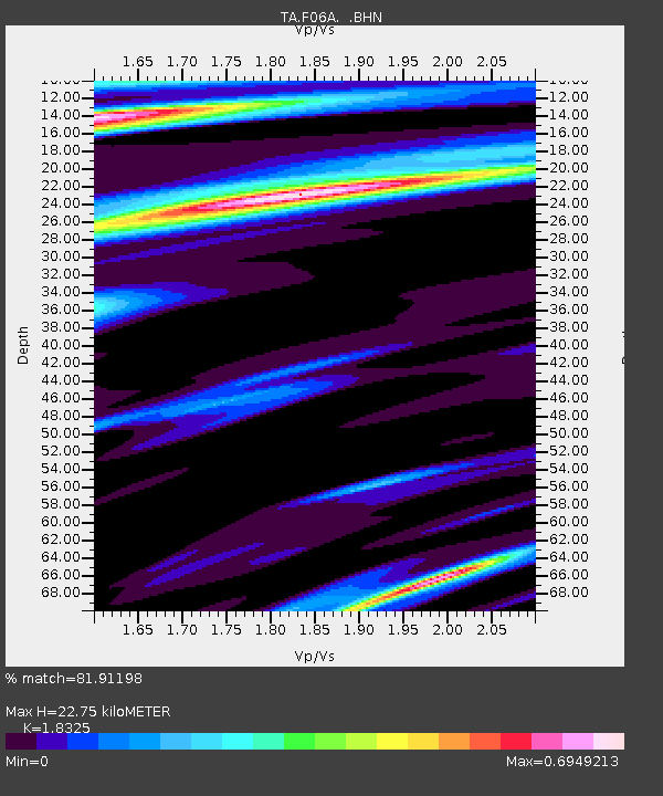
| Estimated Moho Depth: |
22.75 km |
| Estimated Crust Vp/Vs: |
1.83 |
| Assumed Crust Vp: |
6.597 km/s |
| Estimated Crust Vs: |
3.6 km/s |
| Estimated Crust Poisson's Ratio: |
0.29 |
|
| Radial Match: |
81.91198 % |
| Radial Bump: |
358 |
| Transverse Match: |
73.50399 % |
| Transverse Bump: |
400 |
| SOD ConfigId: |
2564 |
| Insert Time: |
2010-03-07 02:11:12.652 +0000 |
| GWidth: |
2.5 |
| Max Bumps: |
400 |
| Tol: |
0.001 |
|

Signal To Noise
| Channel | StoN | STA | LTA |
| TA:F06A: :BHN:20080204T17:13:05.399016Z | 2.800478 | 9.020061E-7 | 3.2209005E-7 |
| TA:F06A: :BHE:20080204T17:13:05.399016Z | 1.7645493 | 8.909303E-7 | 5.049053E-7 |
| TA:F06A: :BHZ:20080204T17:13:05.399016Z | 3.2845185 | 2.3085404E-6 | 7.0285506E-7 |
| Arrivals |
| Ps | 3.0 SECOND |
| PpPs | 9.5 SECOND |
| PsPs/PpSs | 12 SECOND |


