You are here: Home > Network List > TA - USArray Transportable Network (new EarthScope stations) Stations List
> Station T06C Millerton Lake Dam, Friant, CA, USA > Earthquake Result Viewer
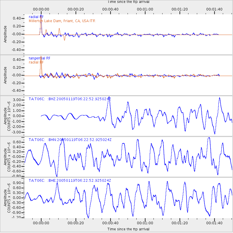
T06C Millerton Lake Dam, Friant, CA, USA - Earthquake Result Viewer

| Earthquake location: |
Off East Coast Of Honshu, Japan |
| Earthquake latitude/longitude: |
34.1/141.5 |
| Earthquake time(UTC): |
2005/01/19 (019) 06:11:36 GMT |
| Earthquake Depth: |
28 km |
| Earthquake Magnitude: |
5.8 MB, 6.4 MS, 6.5 MW, 6.4 MW |
| Earthquake Catalog/Contributor: |
WHDF/NEIC |
|
| Network: |
TA USArray Transportable Network (new EarthScope stations) |
| Station: |
T06C Millerton Lake Dam, Friant, CA, USA |
| Lat/Lon: |
37.01 N/119.71 W |
| Elevation: |
216 m |
|
| Distance: |
76.6 deg |
| Az: |
54.426 deg |
| Baz: |
302.489 deg |
| Ray Param: |
0.050879244 |
| Estimated Moho Depth: |
48.75 km |
| Estimated Crust Vp/Vs: |
1.75 |
| Assumed Crust Vp: |
6.291 km/s |
| Estimated Crust Vs: |
3.6 km/s |
| Estimated Crust Poisson's Ratio: |
0.26 |
|
| Radial Match: |
85.23798 % |
| Radial Bump: |
320 |
| Transverse Match: |
34.961315 % |
| Transverse Bump: |
386 |
| SOD ConfigId: |
132717 |
| Insert Time: |
2010-03-07 02:11:34.151 +0000 |
| GWidth: |
2.5 |
| Max Bumps: |
400 |
| Tol: |
0.001 |
|
Signal To Noise
| Channel | StoN | STA | LTA |
| TA:T06C: :BHN:20050119T06:22:52.925024Z | 1.7063109 | 3.1530382E-7 | 1.8478686E-7 |
| TA:T06C: :BHE:20050119T06:22:52.925024Z | 0.7130208 | 1.6539609E-7 | 2.319653E-7 |
| TA:T06C: :BHZ:20050119T06:22:52.925024Z | 1.0620918 | 3.3469664E-7 | 3.1512965E-7 |
| Arrivals |
| Ps | 6.0 SECOND |
| PpPs | 21 SECOND |
| PsPs/PpSs | 27 SECOND |


