You are here: Home > Network List > TA - USArray Transportable Network (new EarthScope stations) Stations List
> Station T06C Millerton Lake Dam, Friant, CA, USA > Earthquake Result Viewer
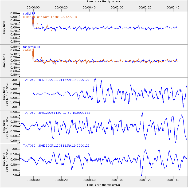
T06C Millerton Lake Dam, Friant, CA, USA - Earthquake Result Viewer

| Earthquake location: |
Unimak Island Region, Alaska |
| Earthquake latitude/longitude: |
53.8/-164.1 |
| Earthquake time(UTC): |
2005/11/20 (324) 12:53:02 GMT |
| Earthquake Depth: |
30 km |
| Earthquake Magnitude: |
5.7 MB, 5.8 MS, 6.2 MW, 6.0 MW |
| Earthquake Catalog/Contributor: |
WHDF/NEIC |
|
| Network: |
TA USArray Transportable Network (new EarthScope stations) |
| Station: |
T06C Millerton Lake Dam, Friant, CA, USA |
| Lat/Lon: |
37.01 N/119.71 W |
| Elevation: |
216 m |
|
| Distance: |
34.7 deg |
| Az: |
100.687 deg |
| Baz: |
313.329 deg |
| Ray Param: |
0.07753638 |
| Estimated Moho Depth: |
41.25 km |
| Estimated Crust Vp/Vs: |
1.88 |
| Assumed Crust Vp: |
6.291 km/s |
| Estimated Crust Vs: |
3.346 km/s |
| Estimated Crust Poisson's Ratio: |
0.30 |
|
| Radial Match: |
84.72521 % |
| Radial Bump: |
372 |
| Transverse Match: |
50.390533 % |
| Transverse Bump: |
400 |
| SOD ConfigId: |
2448 |
| Insert Time: |
2010-03-07 02:11:50.777 +0000 |
| GWidth: |
2.5 |
| Max Bumps: |
400 |
| Tol: |
0.001 |
|
Signal To Noise
| Channel | StoN | STA | LTA |
| TA:T06C: :BHN:20051120T12:59:19.900012Z | 0.8707489 | 1.6290502E-7 | 1.8708612E-7 |
| TA:T06C: :BHE:20051120T12:59:19.900012Z | 2.423608 | 2.4284617E-7 | 1.0020026E-7 |
| TA:T06C: :BHZ:20051120T12:59:19.900012Z | 2.341768 | 2.657702E-7 | 1.1349126E-7 |
| Arrivals |
| Ps | 6.2 SECOND |
| PpPs | 18 SECOND |
| PsPs/PpSs | 24 SECOND |


