You are here: Home > Network List > TA - USArray Transportable Network (new EarthScope stations) Stations List
> Station T06C Millerton Lake Dam, Friant, CA, USA > Earthquake Result Viewer
T06C Millerton Lake Dam, Friant, CA, USA - Earthquake Result Viewer
| Earthquake location: |
Off East Coast Of Honshu, Japan |
| Earthquake latitude/longitude: |
38.1/144.9 |
| Earthquake time(UTC): |
2005/11/14 (318) 21:38:51 GMT |
| Earthquake Depth: |
11 km |
| Earthquake Magnitude: |
6.7 MB, 6.8 MS, 7.0 MW, 6.9 MW |
| Earthquake Catalog/Contributor: |
WHDF/NEIC |
|
| Network: |
TA USArray Transportable Network (new EarthScope stations) |
| Station: |
T06C Millerton Lake Dam, Friant, CA, USA |
| Lat/Lon: |
37.01 N/119.71 W |
| Elevation: |
216 m |
|
| Distance: |
72.0 deg |
| Az: |
56.924 deg |
| Baz: |
304.333 deg |
| Ray Param: |
0.053948183 |
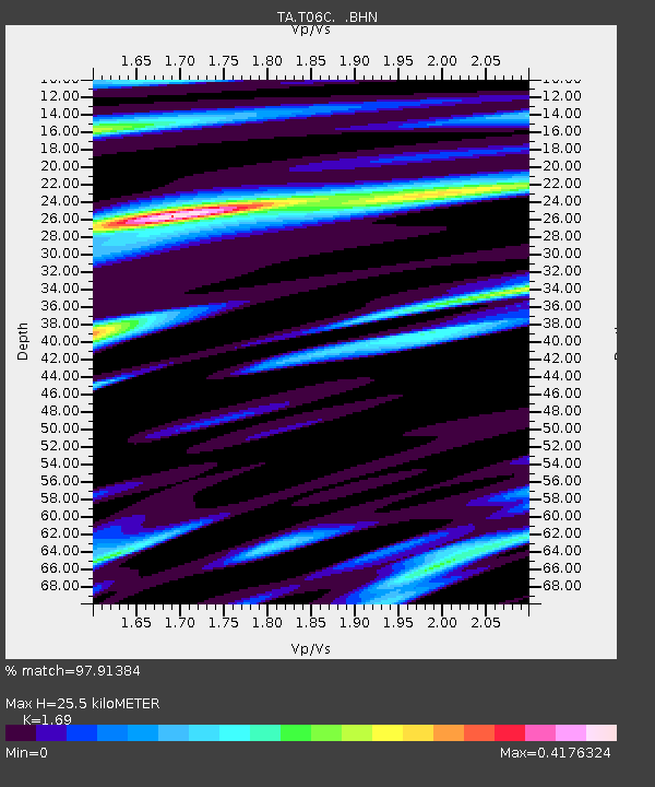
| Estimated Moho Depth: |
25.5 km |
| Estimated Crust Vp/Vs: |
1.69 |
| Assumed Crust Vp: |
6.291 km/s |
| Estimated Crust Vs: |
3.723 km/s |
| Estimated Crust Poisson's Ratio: |
0.23 |
|
| Radial Match: |
97.91384 % |
| Radial Bump: |
306 |
| Transverse Match: |
85.80439 % |
| Transverse Bump: |
400 |
| SOD ConfigId: |
2448 |
| Insert Time: |
2010-03-07 02:11:52.452 +0000 |
| GWidth: |
2.5 |
| Max Bumps: |
400 |
| Tol: |
0.001 |
|
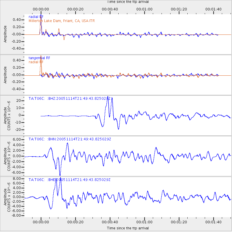
Signal To Noise
| Channel | StoN | STA | LTA |
| TA:T06C: :BHN:20051114T21:49:43.825029Z | 6.0560923 | 6.778394E-7 | 1.11926866E-7 |
| TA:T06C: :BHE:20051114T21:49:43.825029Z | 4.6374516 | 9.407613E-7 | 2.028617E-7 |
| TA:T06C: :BHZ:20051114T21:49:43.825029Z | 12.17661 | 2.9756166E-6 | 2.443715E-7 |
| Arrivals |
| Ps | 2.9 SECOND |
| PpPs | 11 SECOND |
| PsPs/PpSs | 13 SECOND |


