You are here: Home > Network List > TA - USArray Transportable Network (new EarthScope stations) Stations List
> Station F21K Alatna River, AK, USA > Earthquake Result Viewer
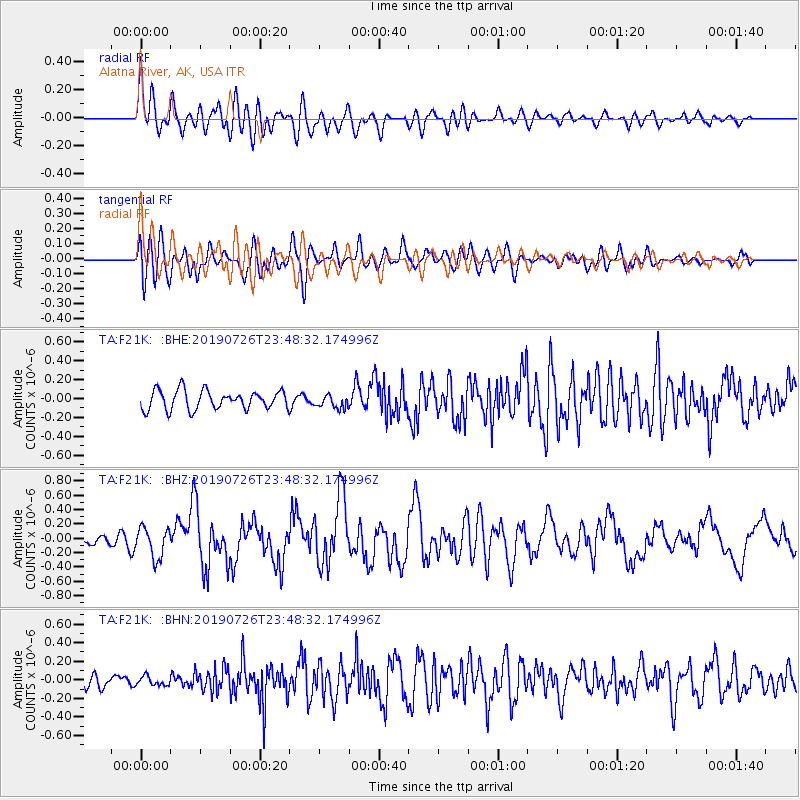
F21K Alatna River, AK, USA - Earthquake Result Viewer
*The percent match for this event was below the threshold and hence no stack was calculated.
| Earthquake location: |
Philippine Islands Region |
| Earthquake latitude/longitude: |
20.8/122.0 |
| Earthquake time(UTC): |
2019/07/26 (207) 23:37:58 GMT |
| Earthquake Depth: |
10 km |
| Earthquake Magnitude: |
5.9 Mww |
| Earthquake Catalog/Contributor: |
NEIC PDE/us |
|
| Network: |
TA USArray Transportable Network (new EarthScope stations) |
| Station: |
F21K Alatna River, AK, USA |
| Lat/Lon: |
67.22 N/153.48 W |
| Elevation: |
597 m |
|
| Distance: |
68.9 deg |
| Az: |
24.548 deg |
| Baz: |
273.409 deg |
| Ray Param: |
$rayparam |
*The percent match for this event was below the threshold and hence was not used in the summary stack. |
|
| Radial Match: |
68.857445 % |
| Radial Bump: |
400 |
| Transverse Match: |
75.479065 % |
| Transverse Bump: |
400 |
| SOD ConfigId: |
19053131 |
| Insert Time: |
2019-08-09 23:42:55.639 +0000 |
| GWidth: |
2.5 |
| Max Bumps: |
400 |
| Tol: |
0.001 |
|
Signal To Noise
| Channel | StoN | STA | LTA |
| TA:F21K: :BHZ:20190726T23:48:32.174996Z | 3.5791683 | 2.1136371E-7 | 5.905386E-8 |
| TA:F21K: :BHN:20190726T23:48:32.174996Z | 0.6602259 | 4.744968E-8 | 7.1868854E-8 |
| TA:F21K: :BHE:20190726T23:48:32.174996Z | 0.6966987 | 6.979726E-8 | 1.0018285E-7 |
| Arrivals |
| Ps | |
| PpPs | |
| PsPs/PpSs | |


