You are here: Home > Network List > TA - USArray Transportable Network (new EarthScope stations) Stations List
> Station T06C Millerton Lake Dam, Friant, CA, USA > Earthquake Result Viewer
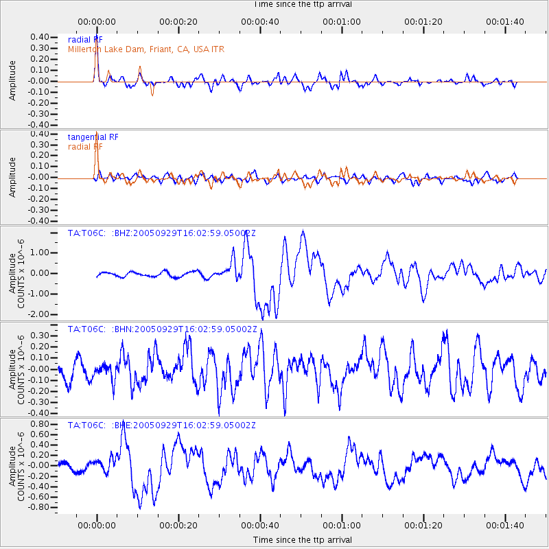
T06C Millerton Lake Dam, Friant, CA, USA - Earthquake Result Viewer

| Earthquake location: |
New Britain Region, P.N.G. |
| Earthquake latitude/longitude: |
-5.4/151.8 |
| Earthquake time(UTC): |
2005/09/29 (272) 15:50:24 GMT |
| Earthquake Depth: |
25 km |
| Earthquake Magnitude: |
5.9 MB, 6.6 MS, 6.7 MW, 6.5 MW |
| Earthquake Catalog/Contributor: |
WHDF/NEIC |
|
| Network: |
TA USArray Transportable Network (new EarthScope stations) |
| Station: |
T06C Millerton Lake Dam, Friant, CA, USA |
| Lat/Lon: |
37.01 N/119.71 W |
| Elevation: |
216 m |
|
| Distance: |
92.0 deg |
| Az: |
53.196 deg |
| Baz: |
264.748 deg |
| Ray Param: |
0.04151951 |
| Estimated Moho Depth: |
23.75 km |
| Estimated Crust Vp/Vs: |
1.89 |
| Assumed Crust Vp: |
6.291 km/s |
| Estimated Crust Vs: |
3.333 km/s |
| Estimated Crust Poisson's Ratio: |
0.30 |
|
| Radial Match: |
84.167244 % |
| Radial Bump: |
400 |
| Transverse Match: |
64.53008 % |
| Transverse Bump: |
400 |
| SOD ConfigId: |
2475 |
| Insert Time: |
2010-03-07 02:12:08.422 +0000 |
| GWidth: |
2.5 |
| Max Bumps: |
400 |
| Tol: |
0.001 |
|
Signal To Noise
| Channel | StoN | STA | LTA |
| TA:T06C: :BHN:20050929T16:02:59.05002Z | 0.6802462 | 6.979916E-8 | 1.02608674E-7 |
| TA:T06C: :BHE:20050929T16:02:59.05002Z | 1.5548962 | 1.3362894E-7 | 8.594075E-8 |
| TA:T06C: :BHZ:20050929T16:02:59.05002Z | 3.9885335 | 4.532233E-7 | 1.13631565E-7 |
| Arrivals |
| Ps | 3.4 SECOND |
| PpPs | 11 SECOND |
| PsPs/PpSs | 14 SECOND |


