You are here: Home > Network List > TA - USArray Transportable Network (new EarthScope stations) Stations List
> Station H23K Yukon River, AK, USA > Earthquake Result Viewer
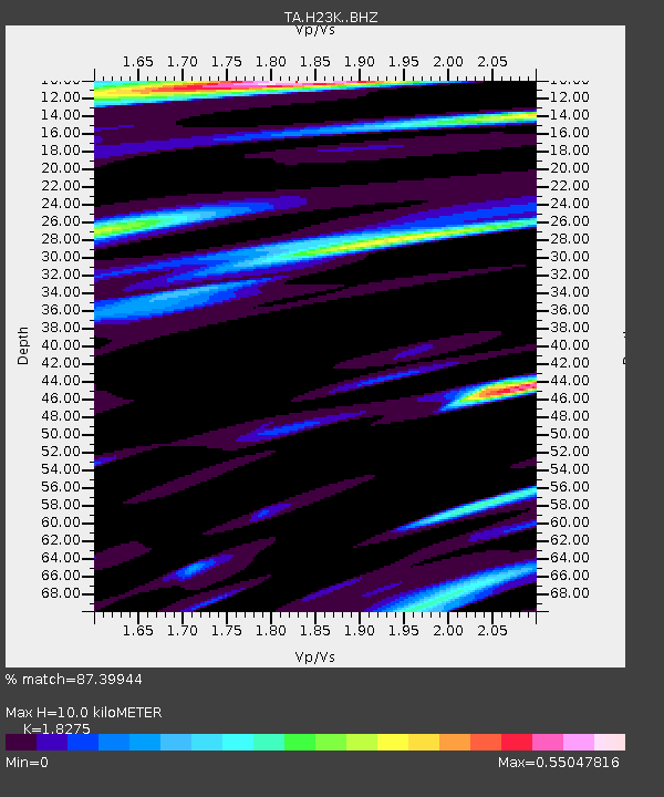
H23K Yukon River, AK, USA - Earthquake Result Viewer
| Earthquake location: |
Philippine Islands Region |
| Earthquake latitude/longitude: |
20.8/122.0 |
| Earthquake time(UTC): |
2019/07/26 (207) 23:37:58 GMT |
| Earthquake Depth: |
10 km |
| Earthquake Magnitude: |
5.9 Mww |
| Earthquake Catalog/Contributor: |
NEIC PDE/us |
|
| Network: |
TA USArray Transportable Network (new EarthScope stations) |
| Station: |
H23K Yukon River, AK, USA |
| Lat/Lon: |
65.83 N/149.54 W |
| Elevation: |
617 m |
|
| Distance: |
70.6 deg |
| Az: |
25.877 deg |
| Baz: |
277.479 deg |
| Ray Param: |
0.054873355 |
| Estimated Moho Depth: |
10.0 km |
| Estimated Crust Vp/Vs: |
1.83 |
| Assumed Crust Vp: |
6.566 km/s |
| Estimated Crust Vs: |
3.593 km/s |
| Estimated Crust Poisson's Ratio: |
0.29 |
|
| Radial Match: |
87.39944 % |
| Radial Bump: |
400 |
| Transverse Match: |
82.86795 % |
| Transverse Bump: |
400 |
| SOD ConfigId: |
19053131 |
| Insert Time: |
2019-08-09 23:43:07.227 +0000 |
| GWidth: |
2.5 |
| Max Bumps: |
400 |
| Tol: |
0.001 |
|

Signal To Noise
| Channel | StoN | STA | LTA |
| TA:H23K: :BHZ:20190726T23:48:42.649972Z | 4.6735954 | 3.3639134E-7 | 7.197699E-8 |
| TA:H23K: :BHN:20190726T23:48:42.649972Z | 0.90684927 | 5.3171185E-8 | 5.863288E-8 |
| TA:H23K: :BHE:20190726T23:48:42.649972Z | 1.4418848 | 9.359319E-8 | 6.491031E-8 |
| Arrivals |
| Ps | 1.3 SECOND |
| PpPs | 4.1 SECOND |
| PsPs/PpSs | 5.5 SECOND |


