You are here: Home > Network List > TA - USArray Transportable Network (new EarthScope stations) Stations List
> Station M20K Styx River, AK, USA > Earthquake Result Viewer
M20K Styx River, AK, USA - Earthquake Result Viewer
| Earthquake location: |
Philippine Islands Region |
| Earthquake latitude/longitude: |
20.8/122.0 |
| Earthquake time(UTC): |
2019/07/26 (207) 23:37:58 GMT |
| Earthquake Depth: |
10 km |
| Earthquake Magnitude: |
5.9 Mww |
| Earthquake Catalog/Contributor: |
NEIC PDE/us |
|
| Network: |
TA USArray Transportable Network (new EarthScope stations) |
| Station: |
M20K Styx River, AK, USA |
| Lat/Lon: |
61.88 N/153.13 W |
| Elevation: |
1107 m |
|
| Distance: |
69.5 deg |
| Az: |
30.254 deg |
| Baz: |
275.755 deg |
| Ray Param: |
0.055620115 |
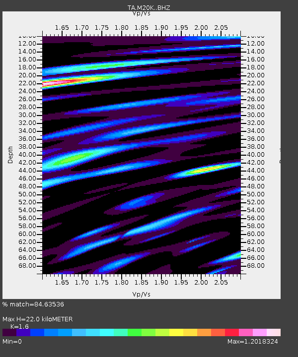
| Estimated Moho Depth: |
22.0 km |
| Estimated Crust Vp/Vs: |
1.60 |
| Assumed Crust Vp: |
6.566 km/s |
| Estimated Crust Vs: |
4.104 km/s |
| Estimated Crust Poisson's Ratio: |
0.18 |
|
| Radial Match: |
84.63536 % |
| Radial Bump: |
400 |
| Transverse Match: |
87.967255 % |
| Transverse Bump: |
400 |
| SOD ConfigId: |
19053131 |
| Insert Time: |
2019-08-09 23:43:28.746 +0000 |
| GWidth: |
2.5 |
| Max Bumps: |
400 |
| Tol: |
0.001 |
|

Signal To Noise
| Channel | StoN | STA | LTA |
| TA:M20K: :BHZ:20190726T23:48:35.774972Z | 3.3560526 | 1.6734991E-7 | 4.9865104E-8 |
| TA:M20K: :BHN:20190726T23:48:35.774972Z | 1.7877796 | 8.396979E-8 | 4.696876E-8 |
| TA:M20K: :BHE:20190726T23:48:35.774972Z | 1.2843688 | 5.979049E-8 | 4.6552433E-8 |
| Arrivals |
| Ps | 2.1 SECOND |
| PpPs | 8.3 SECOND |
| PsPs/PpSs | 10 SECOND |


