You are here: Home > Network List > TA - USArray Transportable Network (new EarthScope stations) Stations List
> Station M30M Minto, Yukon, CA > Earthquake Result Viewer
M30M Minto, Yukon, CA - Earthquake Result Viewer
| Earthquake location: |
Philippine Islands Region |
| Earthquake latitude/longitude: |
20.8/122.0 |
| Earthquake time(UTC): |
2019/07/26 (207) 23:37:58 GMT |
| Earthquake Depth: |
10 km |
| Earthquake Magnitude: |
5.9 Mww |
| Earthquake Catalog/Contributor: |
NEIC PDE/us |
|
| Network: |
TA USArray Transportable Network (new EarthScope stations) |
| Station: |
M30M Minto, Yukon, CA |
| Lat/Lon: |
62.58 N/136.79 W |
| Elevation: |
782 m |
|
| Distance: |
76.8 deg |
| Az: |
27.808 deg |
| Baz: |
289.5 deg |
| Ray Param: |
0.05076623 |
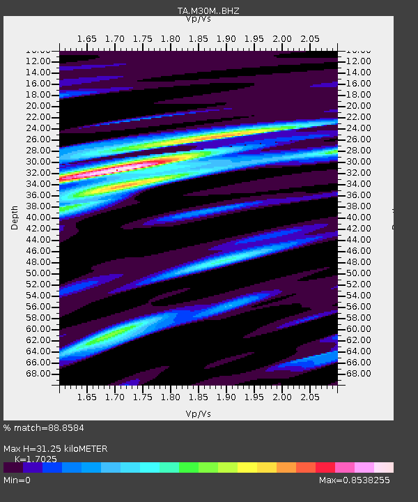
| Estimated Moho Depth: |
31.25 km |
| Estimated Crust Vp/Vs: |
1.70 |
| Assumed Crust Vp: |
6.566 km/s |
| Estimated Crust Vs: |
3.857 km/s |
| Estimated Crust Poisson's Ratio: |
0.24 |
|
| Radial Match: |
88.8584 % |
| Radial Bump: |
400 |
| Transverse Match: |
67.31319 % |
| Transverse Bump: |
400 |
| SOD ConfigId: |
19053131 |
| Insert Time: |
2019-08-09 23:43:32.720 +0000 |
| GWidth: |
2.5 |
| Max Bumps: |
400 |
| Tol: |
0.001 |
|

Signal To Noise
| Channel | StoN | STA | LTA |
| TA:M30M: :BHZ:20190726T23:49:18.799996Z | 2.5948427 | 1.6609037E-7 | 6.400788E-8 |
| TA:M30M: :BHN:20190726T23:49:18.799996Z | 1.0913333 | 6.449657E-8 | 5.9098877E-8 |
| TA:M30M: :BHE:20190726T23:49:18.799996Z | 1.4276313 | 8.622535E-8 | 6.039749E-8 |
| Arrivals |
| Ps | 3.5 SECOND |
| PpPs | 12 SECOND |
| PsPs/PpSs | 16 SECOND |


