You are here: Home > Network List > TA - USArray Transportable Network (new EarthScope stations) Stations List
> Station Q19K Cape Douglas, AK, USA > Earthquake Result Viewer
Q19K Cape Douglas, AK, USA - Earthquake Result Viewer
| Earthquake location: |
Philippine Islands Region |
| Earthquake latitude/longitude: |
20.8/122.0 |
| Earthquake time(UTC): |
2019/07/26 (207) 23:37:58 GMT |
| Earthquake Depth: |
10 km |
| Earthquake Magnitude: |
5.9 Mww |
| Earthquake Catalog/Contributor: |
NEIC PDE/us |
|
| Network: |
TA USArray Transportable Network (new EarthScope stations) |
| Station: |
Q19K Cape Douglas, AK, USA |
| Lat/Lon: |
58.93 N/153.64 W |
| Elevation: |
631 m |
|
| Distance: |
69.5 deg |
| Az: |
33.429 deg |
| Baz: |
276.421 deg |
| Ray Param: |
0.055579547 |
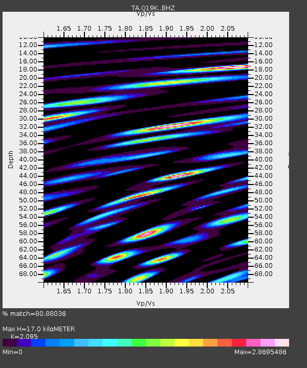
| Estimated Moho Depth: |
17.0 km |
| Estimated Crust Vp/Vs: |
2.10 |
| Assumed Crust Vp: |
5.989 km/s |
| Estimated Crust Vs: |
2.859 km/s |
| Estimated Crust Poisson's Ratio: |
0.35 |
|
| Radial Match: |
80.88036 % |
| Radial Bump: |
400 |
| Transverse Match: |
81.47665 % |
| Transverse Bump: |
400 |
| SOD ConfigId: |
19053131 |
| Insert Time: |
2019-08-09 23:43:46.516 +0000 |
| GWidth: |
2.5 |
| Max Bumps: |
400 |
| Tol: |
0.001 |
|

Signal To Noise
| Channel | StoN | STA | LTA |
| TA:Q19K: :BHZ:20190726T23:48:36.149972Z | 3.889221 | 3.730384E-7 | 9.5915965E-8 |
| TA:Q19K: :BHN:20190726T23:48:36.149972Z | 0.9681945 | 2.0521277E-7 | 2.1195407E-7 |
| TA:Q19K: :BHE:20190726T23:48:36.149972Z | 1.4567436 | 3.5726114E-7 | 2.452464E-7 |
| Arrivals |
| Ps | 3.2 SECOND |
| PpPs | 8.5 SECOND |
| PsPs/PpSs | 12 SECOND |


