You are here: Home > Network List > TA - USArray Transportable Network (new EarthScope stations) Stations List
> Station T06C Millerton Lake Dam, Friant, CA, USA > Earthquake Result Viewer
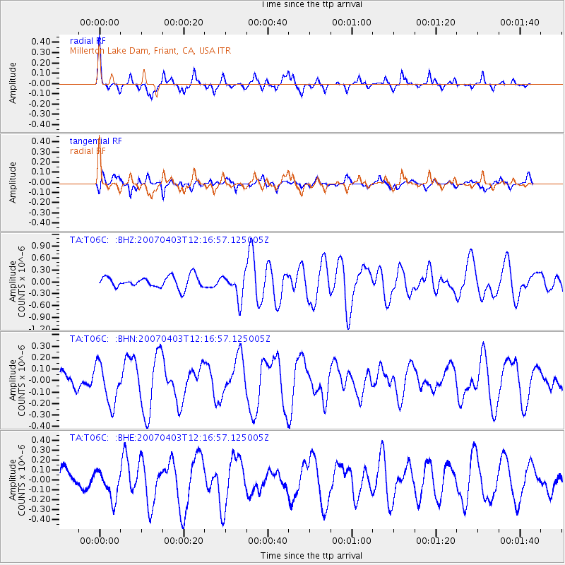
T06C Millerton Lake Dam, Friant, CA, USA - Earthquake Result Viewer

| Earthquake location: |
Solomon Islands |
| Earthquake latitude/longitude: |
-7.9/155.8 |
| Earthquake time(UTC): |
2007/04/03 (093) 12:04:27 GMT |
| Earthquake Depth: |
8.0 km |
| Earthquake Magnitude: |
5.8 MB, 6.0 MS, 6.1 MW, 5.9 MW |
| Earthquake Catalog/Contributor: |
WHDF/NEIC |
|
| Network: |
TA USArray Transportable Network (new EarthScope stations) |
| Station: |
T06C Millerton Lake Dam, Friant, CA, USA |
| Lat/Lon: |
37.01 N/119.71 W |
| Elevation: |
216 m |
|
| Distance: |
90.3 deg |
| Az: |
52.827 deg |
| Baz: |
260.461 deg |
| Ray Param: |
0.04168352 |
| Estimated Moho Depth: |
38.25 km |
| Estimated Crust Vp/Vs: |
1.61 |
| Assumed Crust Vp: |
6.291 km/s |
| Estimated Crust Vs: |
3.914 km/s |
| Estimated Crust Poisson's Ratio: |
0.18 |
|
| Radial Match: |
80.037544 % |
| Radial Bump: |
355 |
| Transverse Match: |
63.367714 % |
| Transverse Bump: |
400 |
| SOD ConfigId: |
2564 |
| Insert Time: |
2010-03-07 02:13:00.266 +0000 |
| GWidth: |
2.5 |
| Max Bumps: |
400 |
| Tol: |
0.001 |
|
Signal To Noise
| Channel | StoN | STA | LTA |
| TA:T06C: :BHN:20070403T12:16:57.125005Z | 2.016389 | 1.7888398E-7 | 8.8715026E-8 |
| TA:T06C: :BHE:20070403T12:16:57.125005Z | 1.0654923 | 1.4369634E-7 | 1.3486381E-7 |
| TA:T06C: :BHZ:20070403T12:16:57.125005Z | 2.267384 | 3.281987E-7 | 1.4474772E-7 |
| Arrivals |
| Ps | 3.8 SECOND |
| PpPs | 16 SECOND |
| PsPs/PpSs | 19 SECOND |


