You are here: Home > Network List > TA - USArray Transportable Network (new EarthScope stations) Stations List
> Station T06C Millerton Lake Dam, Friant, CA, USA > Earthquake Result Viewer
T06C Millerton Lake Dam, Friant, CA, USA - Earthquake Result Viewer
| Earthquake location: |
Vanuatu Islands |
| Earthquake latitude/longitude: |
-20.6/169.4 |
| Earthquake time(UTC): |
2007/03/25 (084) 00:40:01 GMT |
| Earthquake Depth: |
34 km |
| Earthquake Magnitude: |
6.5 MB, 7.0 MS, 7.1 MW, 7.1 MW |
| Earthquake Catalog/Contributor: |
WHDF/NEIC |
|
| Network: |
TA USArray Transportable Network (new EarthScope stations) |
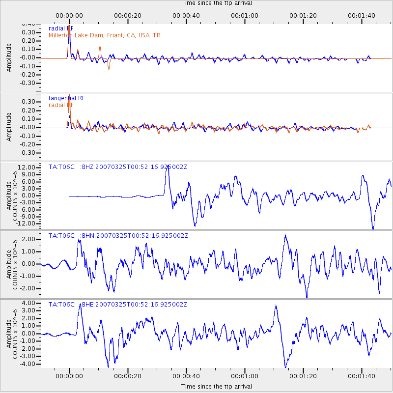
| Station: |
T06C Millerton Lake Dam, Friant, CA, USA |
| Lat/Lon: |
37.01 N/119.71 W |
| Elevation: |
216 m |
|
| Distance: |
88.0 deg |
| Az: |
49.205 deg |
| Baz: |
242.361 deg |
| Ray Param: |
0.042878073 |
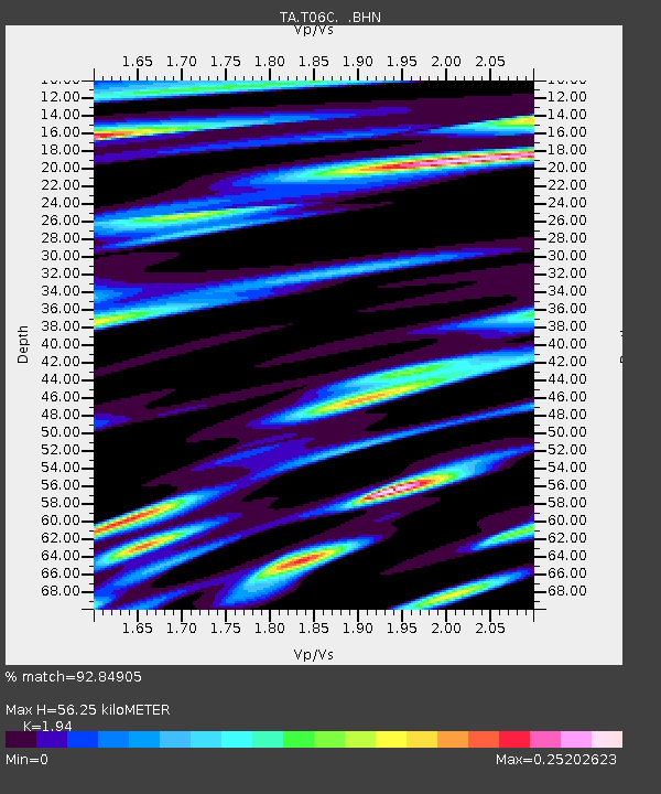
| Estimated Moho Depth: |
56.25 km |
| Estimated Crust Vp/Vs: |
1.94 |
| Assumed Crust Vp: |
6.291 km/s |
| Estimated Crust Vs: |
3.243 km/s |
| Estimated Crust Poisson's Ratio: |
0.32 |
|
| Radial Match: |
92.84905 % |
| Radial Bump: |
360 |
| Transverse Match: |
75.389496 % |
| Transverse Bump: |
400 |
| SOD ConfigId: |
2564 |
| Insert Time: |
2010-03-07 02:13:03.019 +0000 |
| GWidth: |
2.5 |
| Max Bumps: |
400 |
| Tol: |
0.001 |
|
Signal To Noise
| Channel | StoN | STA | LTA |
| TA:T06C: :BHN:20070325T00:52:16.925002Z | 5.710743 | 9.805264E-7 | 1.7169856E-7 |
| TA:T06C: :BHE:20070325T00:52:16.925002Z | 18.45855 | 1.7196471E-6 | 9.316263E-8 |
| TA:T06C: :BHZ:20070325T00:52:16.925002Z | 34.423283 | 5.6131144E-6 | 1.6306156E-7 |
| Arrivals |
| Ps | 8.6 SECOND |
| PpPs | 26 SECOND |
| PsPs/PpSs | 34 SECOND |


