You are here: Home > Network List > TA - USArray Transportable Network (new EarthScope stations) Stations List
> Station T06C Millerton Lake Dam, Friant, CA, USA > Earthquake Result Viewer
T06C Millerton Lake Dam, Friant, CA, USA - Earthquake Result Viewer
| Earthquake location: |
South Of Panama |
| Earthquake latitude/longitude: |
4.6/-78.5 |
| Earthquake time(UTC): |
2007/03/18 (077) 02:11:05 GMT |
| Earthquake Depth: |
8.0 km |
| Earthquake Magnitude: |
6.4 MB, 5.7 MS, 6.2 MW, 6.1 MW |
| Earthquake Catalog/Contributor: |
WHDF/NEIC |
|
| Network: |
TA USArray Transportable Network (new EarthScope stations) |
| Station: |
T06C Millerton Lake Dam, Friant, CA, USA |
| Lat/Lon: |
37.01 N/119.71 W |
| Elevation: |
216 m |
|
| Distance: |
49.6 deg |
| Az: |
316.184 deg |
| Baz: |
120.441 deg |
| Ray Param: |
0.0685934 |
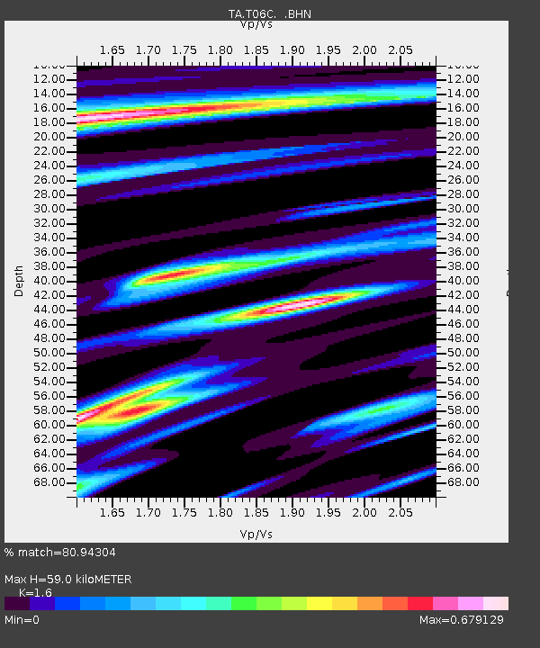
| Estimated Moho Depth: |
59.0 km |
| Estimated Crust Vp/Vs: |
1.60 |
| Assumed Crust Vp: |
6.291 km/s |
| Estimated Crust Vs: |
3.932 km/s |
| Estimated Crust Poisson's Ratio: |
0.18 |
|
| Radial Match: |
80.94304 % |
| Radial Bump: |
347 |
| Transverse Match: |
73.6247 % |
| Transverse Bump: |
354 |
| SOD ConfigId: |
2564 |
| Insert Time: |
2010-03-07 02:13:04.666 +0000 |
| GWidth: |
2.5 |
| Max Bumps: |
400 |
| Tol: |
0.001 |
|
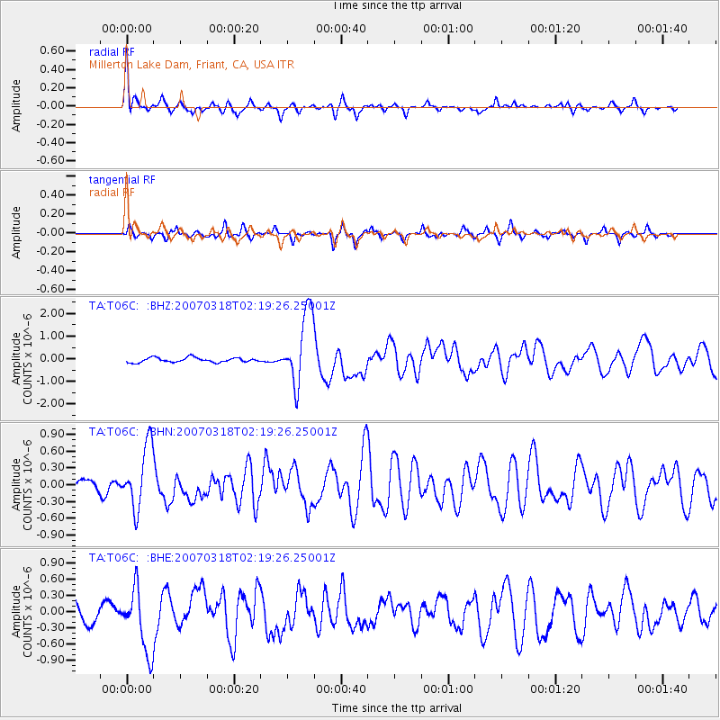
Signal To Noise
| Channel | StoN | STA | LTA |
| TA:T06C: :BHN:20070318T02:19:26.25001Z | 6.7738147 | 5.6270625E-7 | 8.30708E-8 |
| TA:T06C: :BHE:20070318T02:19:26.25001Z | 3.7302775 | 5.893361E-7 | 1.5798719E-7 |
| TA:T06C: :BHZ:20070318T02:19:26.25001Z | 15.976954 | 1.6099192E-6 | 1.00765085E-7 |
| Arrivals |
| Ps | 6.0 SECOND |
| PpPs | 23 SECOND |
| PsPs/PpSs | 29 SECOND |


