You are here: Home > Network List > TA - USArray Transportable Network (new EarthScope stations) Stations List
> Station T06C Millerton Lake Dam, Friant, CA, USA > Earthquake Result Viewer
T06C Millerton Lake Dam, Friant, CA, USA - Earthquake Result Viewer

| Earthquake location: |
Kermadec Islands, New Zealand |
| Earthquake latitude/longitude: |
-29.8/-178.0 |
| Earthquake time(UTC): |
2007/01/31 (031) 03:15:52 GMT |
| Earthquake Depth: |
34 km |
| Earthquake Magnitude: |
6.1 MB, 6.3 MS, 6.5 MW, 6.4 MW |
| Earthquake Catalog/Contributor: |
WHDF/NEIC |
|
| Network: |
TA USArray Transportable Network (new EarthScope stations) |
| Station: |
T06C Millerton Lake Dam, Friant, CA, USA |
| Lat/Lon: |
37.01 N/119.71 W |
| Elevation: |
216 m |
|
| Distance: |
86.0 deg |
| Az: |
43.053 deg |
| Baz: |
227.855 deg |
| Ray Param: |
0.0443142 |
| Estimated Moho Depth: |
69.5 km |
| Estimated Crust Vp/Vs: |
1.60 |
| Assumed Crust Vp: |
6.291 km/s |
| Estimated Crust Vs: |
3.932 km/s |
| Estimated Crust Poisson's Ratio: |
0.18 |
|
| Radial Match: |
90.79068 % |
| Radial Bump: |
400 |
| Transverse Match: |
65.29112 % |
| Transverse Bump: |
400 |
| SOD ConfigId: |
2564 |
| Insert Time: |
2010-03-07 02:13:06.050 +0000 |
| GWidth: |
2.5 |
| Max Bumps: |
400 |
| Tol: |
0.001 |
|
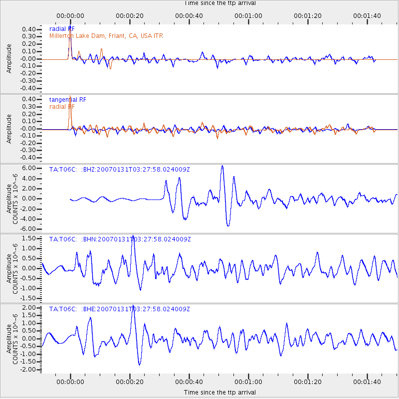
Signal To Noise
| Channel | StoN | STA | LTA |
| TA:T06C: :BHN:20070131T03:27:58.024009Z | 1.6436303 | 3.1163484E-7 | 1.8960155E-7 |
| TA:T06C: :BHE:20070131T03:27:58.024009Z | 1.7646179 | 4.65241E-7 | 2.636497E-7 |
| TA:T06C: :BHZ:20070131T03:27:58.024009Z | 6.200633 | 1.6055125E-6 | 2.589272E-7 |
| Arrivals |
| Ps | 6.8 SECOND |
| PpPs | 28 SECOND |
| PsPs/PpSs | 35 SECOND |


